All Stories

Optical Sensors: Enabling Explorers to See the Depths Like We See the Surface

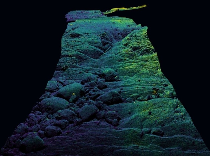
Human ingenuity has led to a world of discovery, yet our ocean’s deepest secrets remain shrouded in darkness. The deep sea covers approximately 65% of the Earth’s surface and a has remained largely undocumented, with surveys being limited to low-resolution mapping from surface vessels and satellites, and localized observation with submersibles.

Optical Sensors: Enabling Explorers to See the Depths Like We See the Surface

The First Port on the Journey to Automation

Have you ever wondered how to significantly reduce the amount of vessel time required to conduct inspections on seabed assets? How can you both mitigate risk and minimize your carbon footprint when inspecting subsea elements?

The First Port on the Journey to Automation

Defining a Sub-Category for Ocean Exploration

For centuries, civilizations have attempted to engineer vehicles to transport people below the waterline in the name of subsea exploration. For the most part, however, Deep Submergence Vehicles (DSVs) remained the purview of science fiction protagonists until twentieth-century advances in mechanical propulsion and sonar extended their reach and navigational capacity, most notably for defense applications.

Defining a Sub-Category for Ocean Exploration

Rediscovering USS Nevada

MAPPING AN UNDERSEA MUSEUM

As bathymetric mapping and hydrographic surveys tackle the goal of a complete mapping of the global seabed in the next decades, an increasing number of highly significant shipwrecks and lost aircraft will be found. In some cases, this will resolve mysteries past and present, like Amelia Earhart’s plane and flight MH370, or long forgotten missing ships that never reached port.

Rediscovering USS Nevada

Democratizing Data by Simplifying Multibeam Deployment and Operation

Creating a map of the seabed is a complex task, to say the least, and one that has traditionally relied on the data acquisition skills of professional hydrographers. While their experience and expertise will always be in demand, developments in marine survey workflow, technologies and multibeam (MBES) system integration and installation are coming together to create a simplified and more automated approach to marine survey.

Democratizing Data by Simplifying Multibeam Deployment and Operation

Driving Safer and Greener Data Acquisition

In March 2021, it was announced that marine robotics company Ocean Infinity had acquired industry-leading survey company, MMT. Together, these two companies combine huge ambition, best-in-class robotic technology, and an unrivalled track record in the offshore industry.

Driving Safer and Greener Data Acquisition
Image

Corporate Headquarters

Ocean News & Technology
is a publication of TSC Strategic

8502 SW Kansas Ave
Stuart, FL 34997
info@tscpublishing.com