Rediscovering USS Nevada
James Delgado, Michael Brennan, and Josh Broussard
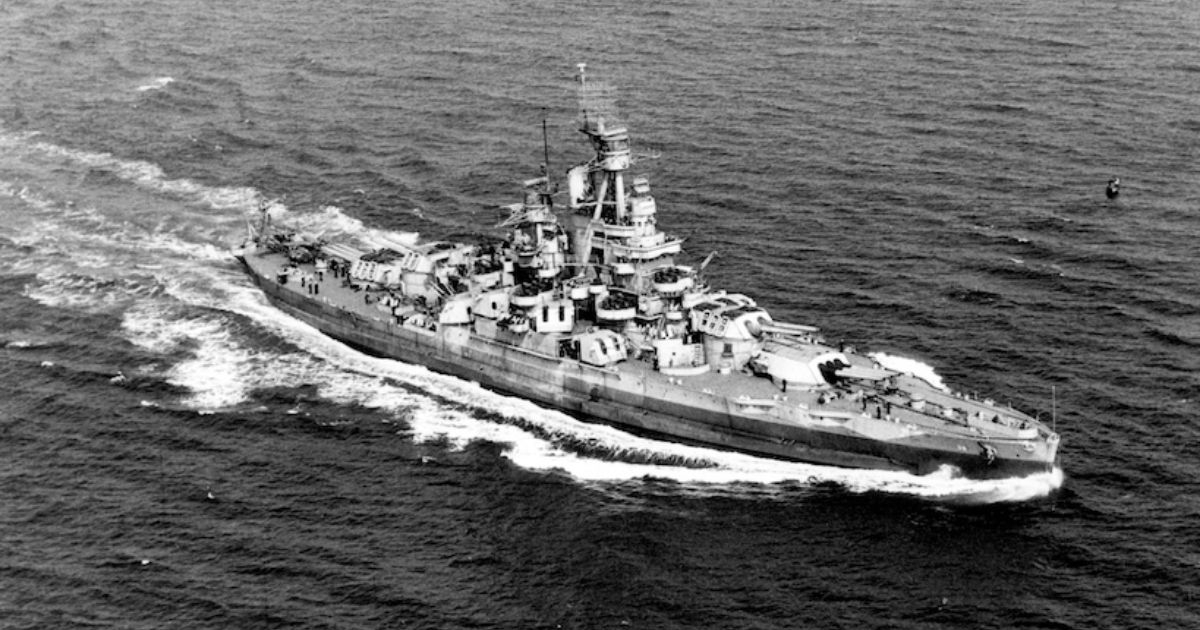
USS Nevada (BB-36) underway off the Atlantic coast of the United States, September 17, 1944. (Photo credit: Official U.S. Navy Photograph, Naval History and Heritage Command)
MAPPING AN UNDERSEA MUSEUM
As bathymetric mapping and hydrographic surveys tackle the goal of a complete mapping of the global seabed in the next decades, an increasing number of highly significant shipwrecks and lost aircraft will be found. In some cases, this will resolve mysteries past and present, like Amelia Earhart’s plane and flight MH370, or long forgotten missing ships that never reached port.
Recently, Ocean Infinity and SEARCH, Inc. worked together to maximize mapping opportunities and more efficiently do just that. The wreck in question was not lost, but sunk after a storied career, which included as a target for two atomic bombs. Lying at roughly defined coordinates three miles deep and sixty miles off Oahu, the wreck of the battleship USS Nevada was located with autonomous HUGIN vehicles that covered a hundred square miles of uncharted seabed in a matter of hours.
Over the course of a 24-hour period, the wreck site was mapped, revealing a scattered debris field that included the intact, overturned hull of the veteran battleship. Among the debris field lay the superstructure, turrets, and portions of the ship that had fallen from the surface during five days of prolonged naval gunfire and torpedoes to sink Nevada—a ship that already had a reputation of being “too tough to die.” A prolonged ROV dive completed a comprehensive documentation of the wreck site, which now rests in the great museum of the deep. The key to success in this mission was the unique capabilities of AUVs, their instrumentation, and the concept of utilizing a suite of robotic vehicles in a cost and time effective manner, while also using best practices for mapping and detailed characterization of what rests in a hitherto uncharted, unknown deep ocean environment.
The mission was not planned, but came as a sudden opportunity in April 2020, at the start of the COVID-19 pandemic. Both of our companies had been discussing the potential for working together given our mutual interests, backgrounds and different assets and skills. Ocean Infinity, both U.K. and U.S. based, was then operating a small fleet on the world’s oceans. Their smaller fleet of fourteen HUGIN autonomous underwater vehicles, and their remotely operated vehicles, which are especially significant for deep sea survey and discovery. This was tested and proved with Ocean Infinity’s successful searches for and surveys of the wrecks of the Argentine submarine ARA San Juan, the bulk carrier Stellar Daisy, the Ro-Ro Grande America and the French submarine Minerve from 2018 to 2019.
TECHNOLOGY NARROWS THE SEARCH
The technology, while field-tested and known in the industry, is a game-changer when multiple vehicles can be deployed simultaneously, all equipped with multiple sonars and digital imaging systems, including high resolution synthetic aperture sonar. and capable of detailed, centimeter-level resolution survey at depths up to 6,000 meters. While this mission again demonstrated the ability of the tech and the team to find a deep-sea shipwreck quickly, it also demonstrated how much more efficient the systems and approach are when assessing the needs for high-resolution deep-sea survey and mapping.
SEARCH and its team have been in the forefront of deep-sea archaeology for two decades. As the two companies discussed partnership on projects, the realization of a repositioning cruise and Pacific Constructor’s imminent arrival at Honolulu meant that we could partner on a quick mission of opportunity to find USS Nevada when Pacific Constructor passed within miles of the rough position for the wreck. Despite being sunk in modern times in a highly publicized target practice exercise that lasted for five days with battleships and destroyers shelling, onboard explosives and at last aerial torpedoes, the exact location of USS Nevada was a rough position noted in classified logbooks of the ships that participated in the exercise in 1948. Those now declassified logbooks had been studied by Pam Orlando of NOAA’s Maritime Heritage Program as part of an assessment of ships subjected to atomic testing and subsequently scuttled. Three different positions from the logs, when plotted on a chart, yielded a hundred square mile search “box” in those three-mile-deep waters.
RECAPTURING HISTORY
Other than having rough coordinates and a historical and archaeological interest, why Nevada? USS Nevada was an iconic prewar dreadnought style battleship that was state-of-the-art when launched in time for World War I. Nevada gained fame and its iconic status at Pearl Harbor on December 7, 1941. Strafed, bombed and torpedoed, Nevada was the only battleship to get under way that day, a brave sortie that inspired all who watched it steam out, guns blazing at attacking aircraft. While run ashore to avoid sinking, Nevada was refloated and repaired and went on to fight in the Atlantic and Pacific theaters of war. It was at D-Day, and off Okinawa and Iwo Jima, surviving a kamikaze attack that hit it and killed or wounded sixty of the crew. At the end of the war, Nevada was known as the toughest ship in the U.S. Navy. It was a ship that would not die. The discovery of Nevada in April 2020 was a perfect reminder to a nation and a world ravaged by COVID-19 that the human spirit is resilient and indomitable.
Selected for the first atomic bomb tests in 1946 at Bikini Atoll, Nevada was the aiming point for the first test, but survived that and the next test. Irradiated and battered, but still afloat, Nevada was towed to Pearl Harbor for detailed examination before being scuttled in 1948. Seventy-two years later, our focused deep-sea survey rediscovered and mapped Nevada and the surrounding seabed in just under twenty-four hours. As the data from the initial AUV deployment was quickly processed, the ROV started its drop to the sea floor. An eight-hour dive followed, revealing the ship as we joined via satellite to work remotely and COVID-19 safely with the onboard team to characterize and assess history once hidden in the deep sea.
The mission was a successful test of the systems, technology and teams. It underscored the cost-efficiency of ocean survey with these tools and approach. The future is here, as demonstrated with this powerful reminder from our past. Let’s get out there and efficiently survey, discover and better understand our planet’s final frontier.
This story was originally featured in ON&T June 2021. Click here to read more.