Democratizing Data by Simplifying Multibeam Deployment and Operation
Sören Themann
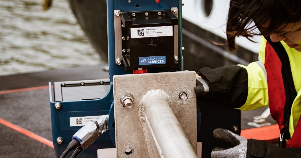
iHSS was designed to overcome mobilization and operational challenges of multibeam echosounders. (Image credit: Subsea Europe Services)
Creating a map of the seabed is a complex task, to say the least, and one that has traditionally relied on the data acquisition skills of professional hydrographers. While their experience and expertise will always be in demand, developments in marine survey workflow, technologies and multibeam (MBES) system integration and installation are coming together to create a simplified and more automated approach to marine survey.
The goal is to unlock data acquisition capabilities for companies and organizations that don’t have the need or budget for a permanent in-house marine survey department staffed by hydrographers, but still require accurate marine data, albeit not regularly.
Consider a (theoretical) developer planning a wind farm installation project. Due to the risk of not proceeding beyond the Final Investment Decision (FID) stage, developers often seek to minimize investment in the early phases, which could, for example, limit funding for essential transmission cable planning and routing and make it harder to access resources such as the services of a professional marine survey company. But could a simpler approach allow the developer save money by collecting their own data—at least in the pre-FID stage?
Reducing the complexity of data acquisition is only possible when we look at the entire value chain. It starts with a) procuring, configuring and installing the survey system on the chosen vessel, then b) operating the MBES to produce quality results and c), processing data to create an accurate, user-friendly final product from the data collected. The work is diverse, but more effective and less complex ways of working already exist at all phases.
(A) PROCURE, CONFIGURE AND INSTALL
After selecting a vessel, the first challenge is securing the required hydroacoustic technology. As turnkey equipment, MBES systems are not easy to acquire, especially if time is of the essence. It pays to plan your survey well in advance and give your provider as much notice as possible to minimalize staff/ vessel downtime while waiting. New business models such as a subscription service offered by Subsea Europe Services are designed to ensure access to hydrographic equipment exactly when it’s needed by allowing long-term pre-booking in a ‘time-share’ like fashion.
But it’s the nature of the technology that causes the biggest need to simplify. The MBES is approximately 10% of the entire system needed onboard. Traditionally, a client needs a deep understanding of what systems are necessary to piece together their survey platform, but pre-integration of the relevant components by professionals can reduce the need for expertise down the line.
Approximately 90% of the work can be done before the system even leaves the office. All sensors can be integrated, correct cables selected, and software and firmware updated. Further, it’s possible to set the MBES offset calculations for any mounting system and vessel size or motion at this stage, which massively simplifies commissioning of the MBES system on site at the vessel.
This pre-configuration and testing are key to a new MBES solution from Subsea Europe Services known as the ‘integrated Hydrographic Survey System’ (iHSS). Delivered as a ‘plug and play’ turnkey package, the iHSS is ready to mobilize with R2Sonic Sonic 2024 or 2020 MBES, sound velocity instruments, workstation and software, I2NS inertial navigation system and flexible mounting. As an integrated package, it is able collect data to the new IHO S-44 Exclusive Order standards and regardless of which MBES is specified, the system can take less than 2 hours to install because everything is ready to go on delivery.
(B) HIGH PERFORMANCE, HIGH PRECISION
The iHSS all-in-one pole mount design places the MBES, Inertial Motion Unit and GNSS antennas in one reference frame with offsets already set prior to delivery, which simplifies installation and reduces potential errors from inconsistent or wrong offsets. This set-up also lowers the technical burden when moving a vessel to new survey areas by road or transport ship; if all systems remain on the same mounting pole, all offsets remain the same for the vessel, so there is no requirement for recalibration.
MBES manufacturers continue to develop easier methods of operation also, which is starting to let non-hydrographers access at least some of the functions required to collect precise data at sea. The R2Sonic ROBO™ mode for instance, is the only automatic MBES feature that relies on empirical data provided by advanced algorithms.
The ROBO™ mode works in conjunction with the Saturation Monitor to set the system gain, which is something that the hydrographer would usually take care of. Employing the complex calculations used to determine the degree of receiver saturation makes the ROBO™ mode intelligent and robust and of course, more experienced users can change the parameters for the auto gain adjustment.
(C) DATA PROCESSING, VESSEL AND OFFICE
The iHSS uses the BeamworX software suite, which provides automated functions to improve workflows and data processing on board. The AutoPatch system enables fully automated MBES patch test calculations, which would normally require the expertise and experience of a marine surveyor. Likewise, the AutoClean app cleans and validates bathymetric and LiDAR point clouds so that the data coming from the vessel to office is already clean without intervention from an expert.
At the post-processing stage, both hydrographers and users with less experience can take advantage of advances in cloud-based data storage and processing systems made by corporations or more specialist subsea industry developers. It’s important to note that while advances made to support professionals in producing final products have certainly simplified data post-processing, hydrographers will always be needed to validate and ensure that output meets client expectations.
STEPS TO AUTONOMY
The Cloud paves the way to bring AI and machine learning to the acquisition and processing of MBES data. In combination with the simplification of the hydrographic processes, technology and operations, we are seeing the first step towards autonomous marine surveying; though from a vessel and marine operations perspective, this is already a reality.
To some extent, autonomous echosounders are also a reality. To bring autonomy to live MBES seafloor surveys where hundreds of variables need to be calculated for every second is still quite challenging, but ongoing simplification and automation efforts will bring us closer and provide operational benefits in the meantime.
There will of course be detractors of what might be described as a ‘dumbing down’ of such a technical field of expertise, but it’s important to understand that most companies and academic organizations engaged in developments that automate marine survey are primarily aiming to help professional surveyors optimize their work. But as more-user friendly technology and simplified workflows become mainstream, there will be more opportunity to ‘democratize’ marine data.
This story was originally featured in ON&T June 2021. Click here to read more.