The Future of Lidar-Assisted Coastal Survey & Inspection
By Travis Hamilton
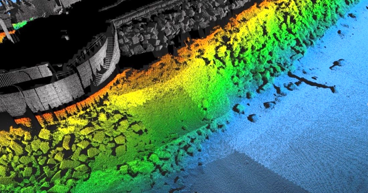
Combined LiDAR scanner and multibeam dataset covering the harbor wall and erosion defenses demonstrating how the two different sensors produce nearly identical data quality and resolution. (Image credit: Teledyne Geospatial)
The scale by which twenty-first-century advances in ocean technology have transformed the programmatic study of our planet’s oceans can often be difficult to contextualize.
Today’s expanding toolkit of marine technologies, replete with uncrewed vehicles, multibeam sonars, and a host of other smart sensors and instrumentation engineered to enable remote sensing, quality data collection, and precise sampling campaigns, would likely leave the early pioneers of coastal survey “all at sea.”
Modern sonar technology, initially developed to counter the growing threat of submarine warfare in World War I & II, was the technical breakthrough that triggered a more ambitious approach to oceanography, and to this day remains the chief protagonist of subsea geospatial exploration missions. However, in recent years, LiDAR (Light Detection And Ranging) systems have played an important supporting role in high-profile campaigns to map the seafloor, measure water depths, and inspect seabed features, including man-made structures and lost shipwrecks.
LiDAR IN THE PACK
LiDAR employs lasers—infrared for topographic scanning or a water-penetrating green for bathymetric measurements—and collects swaths of distance and angle measurements with hundreds of thousands of points per second to produce 3D point cloud surveys. Although LiDAR is a long-established technology, new photonics and optics are stretching its practical uses, from small “pucks’ for the automotive industry, to terrestrial tripod-based systems, to small aerial systems for drones and larger units for fixed-wing aircraft.
As interest in coastal zone mapping increases, LiDAR looks set to play a pivotal role in delivering measurable efficiency gains and better-quality data for a range of stakeholders, including coastal survey and inspection. In particular, small autonomous platforms are making it much easier and cost-effective to deploy LiDAR technology on coastal mapping projects. Rather than needing to deploy an expensive fixed-wing aircraft or research vessel, a compact LiDAR system can be mounted onto a drone to perform an aerial survey, or a mobile LiDAR system can be just as easily incorporated into the payload of a rapidly deployable Uncrewed Surface Vehicle (USV) to gather coastal topographic and bathymetric data in small channels and near critical infrastructure, like bridges and dams.
COASTAL MAPPING
The comprehensive mapping of any target coastal zone demands that operators collect data from above and below the waterline. To ensure this happens seamlessly, LiDAR offers the perfect operational synergy with multibeam echosounders, allowing the full extent of the coastal zone to be efficiently mapped and detailed to similar resolution and accuracy.
This sector-wide need to optimize the field procedures associated with coastal mapping, submerged structure inspections, ports and harbor management, and general asset modeling for offshore planning has been further bolstered by the utility of “digital twins” (virtual model of a physical object) and using remote sensing technologies to perform previously labor-intensive manual tasks like inspection.
Aside from the field-proven efficiency LiDAR can afford operators, there is also a large safety factor at play. The coastal zone is a notoriously hazardous environment and attempting to mobilize crewed vessels in such waters can lead to unacceptable levels of risk. LiDAR introduces an alternate approach that allows the coastal zone to be mapped from either a surface vessel in safer waters or a fully airborne craft.
At Teledyne Geospatial, we have found that for studies aiming to tie together both terrestrial and offshore datasets, the deployment of an airborne bathymetric LiDAR (green laser) can often represent the most efficient tool for mapping large areas of shallow water—up to 70 m deep in ideal conditions.
For mapping coastal waters with more variance, Teledyne Geospatial’s terrestrial scanners, the Optech Polaris and Optech TLS-M3, can be easily installed on a survey boat then quickly transitioned to performing static scans on land, providing the flexibility to capture the above water part of a full dataset in a way that a marine-only system cannot.
We have also developed a lightweight system well-suited to be deployed as a commercial alternative on small USVs. The Optech CL-360 has survey grade range, resolution, and accuracy in a small form factor that allows the performance of larger topographic LiDAR systems to be deployed on small uncrewed platforms, which are most often used in ports, small waterways, and hard-to-access waters.
WORKFLOW EFFICIENCY
This operational choreography between complementary technologies, whereby the chosen LiDAR system maps features above the waterline whilst an echosounder maps below, signals a new era of operational efficiency and accuracy for hydrographic survey. This allows the industry to capture shoreline verification data, map the location of above-surface hazards, outline clearance heights under bridges and powerlines, and much more.
Coastal management professionals, using cooperative platforms, can map coastal zones for ongoing or event-related erosion and provide infrastructure inspections. In the end, through the merging of the above and below waterline data sets, digital twins of infrastructure like dams, breakwaters, wharfs, and bridges can be generated.
Creating seamless workflows is also an important point for allowing LiDAR technology to be easily accepted and integrated into marine survey operations. Teledyne Geospatial brings together high-performance Optech LiDAR systems with highly regarded and trusted CARIS marine software solutions. This ultimately ensures that the LiDAR and echosounder data are collected and processed together in a trusted marine software workflow.
FUTURE APPLICATIONS
As the benefits of survey efficiency and increased resolution of information are becoming better understood and accepted, we expect to see growing interest, trial, and adoption for the use of LiDAR systems in the marine environment. Ongoing technical enhancements will continue to coalesce the disciplines of topographic and bathymetric survey, and ultimately drive the demand for complete and cohesive solutions for simultaneous mapping above and below—a robust subsea-to-sky 3D geospatial capture and visualization solution.
The continued integration of uncrewed platforms—above, on, and below the water—will only further drive the technological development of LiDAR systems and broaden their applicability in the marine industry.
We can expect this to result in market demands pushing for improved workflows for managing the increased volume of data being collected, focusing on aspects of data management, and automated workflows for extracting features out of the datasets, making it easy to produce and disseminate the valuable information from the collected data.
For more information, visit: www.teledynegeospatial.com.
This feature originally appeared in Ocean News & Technology's Magazine December 2022 edition. To read more, access the magazine here.