Ocean Data at Your Fingertips
Joe Wolfel
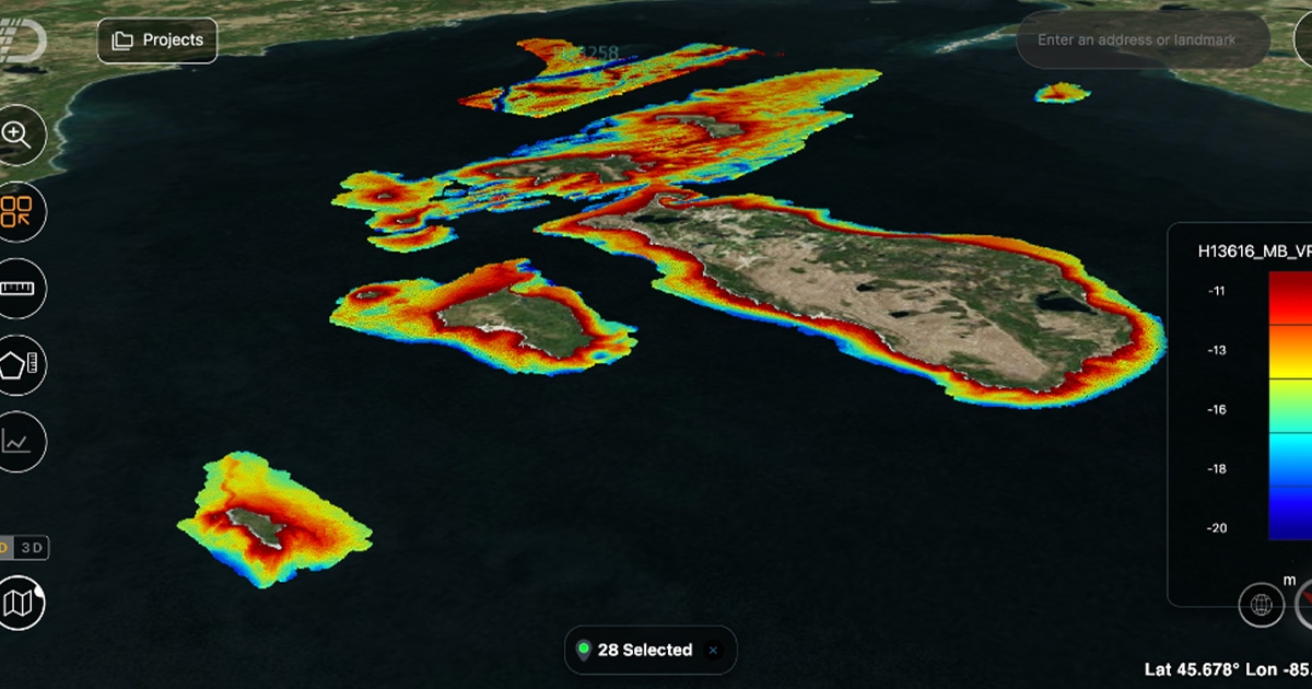
Absolute Ocean’s API allows users to automatically upload and visualize data in near real time. (Image credit: Terradepth)
Texas-based Terradepth was founded in 2018 with a clear vision: to establish new and innovative ways to collect and process ocean data at scale, faster, and more cost-effectively than previously commercially available.
In less than five years as a data-as-a-service business, the team has expanded to incorporate the latest advancements in marine robotics, in particular the deployment of autonomous underwater vehicles (AUVs) to successfully deliver turnkey seafloor hydrographic and geophysical survey solutions to a broadening range of offshore clients. The premise is simple: by investing in the latest generation of fit-for-purpose ocean tech hardware and software, Terradepth helps facilitate smarter data-led decisions across the marine sector.
DEVELOPING DATA SOLUTIONS
In late 2022, Terradepth launched Absolute Ocean, a cloud-based geospatial solution designed to streamline the ways in which survey teams and stakeholders process, manage, and share marine data.
With Absolute Ocean already fully integrated into the operations of several early adopters, the data workflow package is currently being used on a number of high-profile projects ranging from environmental monitoring and construction engineering to offshore energy production and telecommunications infrastructure inspection.
Absolute Ocean was developed in direct response to customer demand. We listened to our customers and recognized the persistent concerns surrounding the safe and reliable transfer of data and analyses across teams and geographies.
This compelled us to create an intuitive always-on platform that allows complex marine data sets to be managed by multiple users all in one place, hence shattering data silos and prioritizing global, enterprise-wide access to vital ocean information.
Absolute Ocean users can easily and securely upload data into the secure cloud database and, from there, can then visualize the data and perform various geospatial analyses. To facilitate information sharing, users are able to generate and share access hyperlinks to base map data sets in 2D and 3D, which can be viewed from a variety of perspectives, scales, and viewing angles, including the option of overlaying third-party maps, such as NOAA’s Electronic Nautical Charts (ENCs).
Terradepth has also populated Absolute Ocean with thousands of publicly available data sets, including side scan sonar, synthetic aperture sonar, magnetometer grids, multibeam bathymetry, LiDAR, and satellite imagery. Access to pre-loaded data and advanced functionality is made available through a graduated subscription pricing structure.
DATA WHEN YOU NEED IT
As one early adopter, Orange Force Marine, learned, Absolute Ocean can also give customers near real-time access to essential data. Orange Force Marine is a specialized commercial marine services company offering “Excellence at Sea” by providing safe, flexible, and reliable vessels; experienced and highly professional mariners; and results-focused project management for a range of multidisciplinary campaigns.
With approximately 25% of the world’s oceans and a mere 15% of the Great Lakes surveyed using high-resolution bathymetric survey technology, Orange Force Marine is leading the charge to ramp up mapping efforts by collecting critical marine data using both traditional survey instrumentation and crowdsourced bathymetry solutions.
Leveraging both their in-field expertise and proprietary technology, Orange Force Marine installs crowdsourced bathymetry (CSB) kits (known as the “Mussel”) on several of their vessels worldwide to automatically capture valuable bathymetric data as their clients conduct their day-to-day deployments. This data is then compiled and shared with the Lakebed 2030 and Seabed 2030 initiatives.
Traditionally, data collected onboard requires manual upload and processing back at shore. Given the longer collection cycles and large amounts of data, this inevitably delays the upload, storing, and analysis of data sets. The longer the deployment, the lengthier the time lags between data capture and data visualization. Further accentuated by potential uncertainties in data transmission, these delays can have a pronounced negative impact on critical decisions relating to at-sea ops and tasking, resulting in a duplication of efforts and inefficient vessel routing.
However, using Absolute Ocean’s application programming interface (API) and the Mussel crowdsourced bathymetry kit, Orange Force Marine can automatically upload and visualize data in near real time instead of waiting for data to be uploaded manually when vessels return to dock. This allows operators and stakeholders to quickly validate the data, confirm quality and coverage, and provide timely feedback to survey clients and collection vessels.
Absolute Ocean’s collaboration feature also allows Orange Force Marine to provide critical survey progress updates and calculate data contributions over a date range or on a per ship or per survey basis. Through the visualization tools in Absolute Ocean, stakeholders can clearly demonstrate the value of crowdsourced bathymetry efforts and highlight areas of good coverage versus areas requiring additional survey time.
DATA SUPPORTED DECISIONS
Traditional approaches to marine survey have long thwarted the ability to efficiently manage, collaborate with, and deliver ocean data, but we now have the hardware and software to support near real-time project management.
Through the automated uploading of data, which in turn is quickly categorized and easily accessed, customers of Absolute Ocean can visualize, validate, and interpret data being captured as it is happening. Therefore, multiple users can provide feedback and input on current operations. For example, a remote observer could review the coverage and immediately communicate with a vessel’s captain to suggest that they adjust operations to cover a certain area or optimize their sea time.
Orange Force Marine’s use of Absolute Ocean results in significant time and fuel savings, along with an opportunity for additional data collection made possible through efficiency and optimization.
According to Orange Force Marine President & Founder Derek Niles, “Absolute Ocean helps us achieve our customer’s goal of mapping the Great Lakes more quickly and efficiently. By incorporating Absolute Ocean into our data pipeline, we’re better able to achieve our vision of ‘Ping to Cloud’ by visualizing the depth data collected almost immediately following the vessel passing over a location on the seabed.”
Absolute Ocean is ultimately about making open impactful ocean data fingertip ready. By working with industry partners like Orange Force Marine to constantly evolve and enhance our cloud-native geospatial data management solutions, Terradepth remains committed to bringing ever greater clarity and understanding to humanity’s relationship with the ocean. Through the democratization of precise and reliable data, we believe in empowering blue economy professionals and stakeholders to advance the sustainable future of our climate, subsea ecosystems, and marine life.
For more information, visit: www.terradepth.com.
This story was originally published in ON&T magazine's August 2023 issue. Click here to read more.