European Contribution to World Seabed Mapping Effort
Ocean News

EMODnet DTM 2018 along the coasts of Greece.
EMODnet Bathymetry, an initiative of the European Commission, is pleased to announce on behalf of the full consortium with all associated collaborators the release of the latest version of the EMODnet Bathymetry Digital Terrain Model (DTM).
With over 33.000 individual tiles downloaded in 2020, this bathymetric product is already widely used in a whole range of applications, from marine science to sustainable ocean governance and blue economy activities.
This new EMODnet Bathymetry product benefited from significant developments and expert inputs in 2020, including new data gathering, reprocessed data, thorough selection of the best data source and use of innovative bathymetric sensors (such as Satellite Derived Bathymetry). It allows users to visualize bathymetric features with greater detail, in addition to providing a powerful 3D visualization functionality covering all European seas, into the Arctic and Barents Sea, and greater accuracy along European coastlines, thanks to the integration of both in water and satellite datasets. It is available free of charge for viewing and downloading, and sharing by OGC web services from the EMODnet Bathymetry portal.
This improved DTM provides users with even greater resolution and coverage of bathymetry across European seas and beyond. These updates contribute to further reducing uncertainty, and are used in real-life settings such as improving society’s ability to forecast storm surges, lowering the risks of damage to coastal and offshore installations and increasing public safety. EMODnet Bathymetry is now the go-to place for oceanographers in providing a base geometry for hydrodynamic models, for marine geologists studying morphological processes, and for biologists and conservation managers who require trusted and high-quality seabed habitat maps, which rely on accurate and high-resolution bathymetry, amongst other parameters. EMODnet Bathymetry also supports a wide range of marine and maritime activities, including the Blue Economy, from the marine dredging sector to the planning of pipeline trajectories, locations of offshore wind farms and planning of harbor extensions.
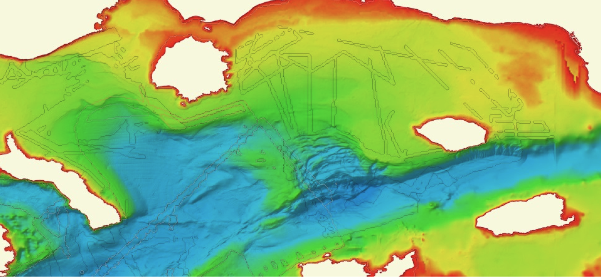 EMODnet DTM 2020 along the coasts of Greece (with new survey tracks highlighted)
After a decade of European collaborations and technological developments, the new EMODnet Bathymetry product release offers:
- DTM with 1/16 * 1/16 arc minutes (circa 115 * 115 meters) grid resolution covering all European seas from the Mediterranean Sea, the Black Sea, the North-East Atlantic Ocean, up to the Arctic Ocean and Barents Sea;
- A source reference layer and a quality index layer pointing directly to one of the 16141 bathymetric survey data sets and 120 composite DTMs used in the 2020 version;
- Catalogues with over 32.000 unique descriptions of data surveys, composite DTMs and Satellite Derived Bathymetry products originating and gathered from European data holders, covering European coasts, sea regions and global oceans, in co-operation with the European SeaDataNet infrastructure;
- Snapshots of bathymetric DTM products at a higher resolution (up to approx. 10m) than the full DTM;
- Best-estimate European coastlines at LAT, MSL, and MHW, determined from satellite data in combination with the Global Tide Surge Model (GTSM)
- Inventory of official baseline and coastline data as collected from 26 national authorities in Europe;
- Powerful 3D visualization functionalities;