Naval Oceanography Demonstrates Capabilities in the Gulf of Mexico
Ocean News
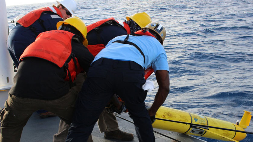
Naval Oceanographic Office crew works together aboard USNS Maury to recover a glider on May 15, 2017, that was deployed in the Gulf of Mexico in March in support of Naval Oceanography Unmanned Systems Operational Demonstration. Deploying unmanned systems in the Gulf of Mexico to collect observational data improved predicted sonar performance in the area.
For several months Naval Meteorology and Oceanography Commands (NAVMETOCCOM) have been conducting operations in the Gulf of Mexico in support of its Unmanned Systems Operational Demonstration, May 31 - June 1.
Operations and observations collected during the demonstration will be integrated on a unique common operational picture at the Combat Readiness Training Center-Battlefield Airmen Center in Gulfport.
"The Mississippi Gulf Coast is extremely suited to nearly all the mission types the Navy addresses," said Rear Adm. Tim Gallaudet, commander, NAVMETOCCOM and oceanographer of the Navy. "When it came to choosing a place to host the first ever unmanned systems operational demonstration, the answer was easy-it was right in our backyard. Our coastline includes riverine, shallow and deep water, barrier islands, harbors and beaches that can be used to simulate missions."
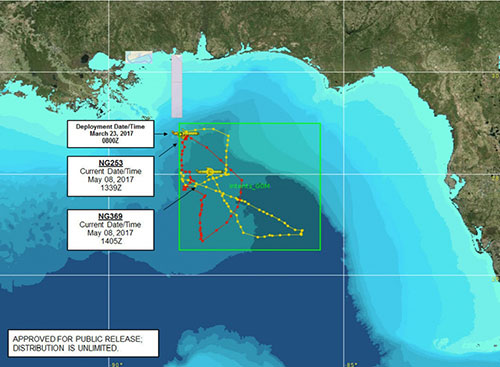 Two gliders were deployed from USNS Maury in the Gulf of Mexico in March in support of Naval Oceanography Unmanned Systems Operational Demonstration. The map details their tracking data as of May 8, 2017. Gliders are autonomous underwater vehicles used to collect a variety of oceanographic data to better understand the ocean environment.
Led by Rear Adm. Gallaudet, the event is providing Naval Oceanography an opportunity to demonstrate existing unmanned systems capabilities, highlight local infrastructure that can be used for additional unmanned systems operations and explore collaborative opportunities between Navy, industry and academia in support of national defense.
To simulate Navy missions for the demonstration and test unmanned systems capabilities, Fleet mission areas such as humanitarian assistance/disaster relief (HA/DR); sea control; theater anti-submarine warfare; intelligence, surveillance and reconnaissance and more were planned.
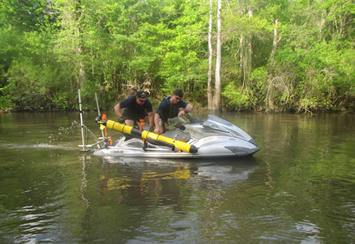 On May 19, 2017, AGC Giannaris (left) and AG2 Simmons with Fleet Survey Team recover an Iver 3 unmanned systems off a rapid littoral survey vessel in the Pearl River at Stennis Space Center, Miss., in support of Naval Oceanography Unmanned Systems Operational Demonstration.
HA/DR was a multi-command demonstration that combined near-shore data collection capabilities near Cat Island and Gulfport Harbor to identify hazards to navigation and provide clear transit and anchorages for incoming support vessels. Personnel deployed Iver 3s and REMUS 100s, which are unmanned systems that collect bathymetry and side scan sonar data. The data was then consolidated and processed to provide water depths, hazards to navigation and tactical recommendation products.
The HA/DR lead Lt. Cmdr. Jessica Garrett said, "Natural disasters can drastically change the coastal landscape and infrastructure. The Mississippi Gulf Coast is definitely not a stranger to that. Deployed Naval Oceanography teams can quickly and efficiently provide environmental updates to the HA/DR commander, expediting relief efforts."
Another exercise employed unmanned systems that communicated with each other to deliver the most accurate and up-to-date environmental assessments. Naval Oceanography tested the use of a littoral battlespace sensing mission van as a forward operating base (FOB) to maintain contact with multiple unmanned systems that were deployed from USNS Maury in the Gulf of Mexico. The two unmanned systems can collect bathymetry and communicate position back to the FOB.
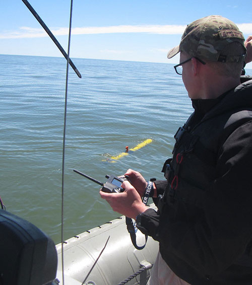 Fleet Survey Team Survey Technician AG2 Jesse Osborne operates an Iver3 unmanned system via radio frequency remote during compass calibration mission in the Gulf of Mexico in preparation for bathymetric data collection in support of Naval Oceanography Unmanned Systems Operational Demonstration Humanitarian Assistance/Disaster Relief support scenario.
These are just two examples; whereas, support for the operational demonstration has been ongoing for months as various Navy commands collaborated with industry and academia to complete exercises in the Gulf of Mexico. The Naval Oceanographic Office worked with the U.S. Air Force 53rd Weather Reconnaissance Squadron "Hurricane Hunters" to deploy profiling floats and drifters to measure conductivity, temperature and depth and ocean currents. Woods Hole Oceanographic Institution used specially-equipped ocean gliders to test advanced techniques in support of anti-submarine warfare. Naval Oceanography also partnered with The University of Southern Mississippi, National Oceanic and Atmospheric Administration and many other Navy commands to produce the nation's first Unmanned Maritime Systems Certification program.
COMNAVMETOCCOM Deputy Commander and Technical Director Dr. Bill Burnett said, "To be able to share what we do right here at home and put all the knowledge gathered into a common operational picture is very exciting for us. Our community should know that there are people working hard every day in support of our nation's defense from right here at Stennis."
COMNAVMETOCCOM directs and oversees more than 2,500 globally-distributed military and civilian personnel who collect, process and exploit environmental information to assist Fleet and Joint Commanders in all warfare areas to make better decisions faster than the adversary.
For more information, click here.