Enhanced Discover Software with Coverage Mapper and Target Logger
Ocean News
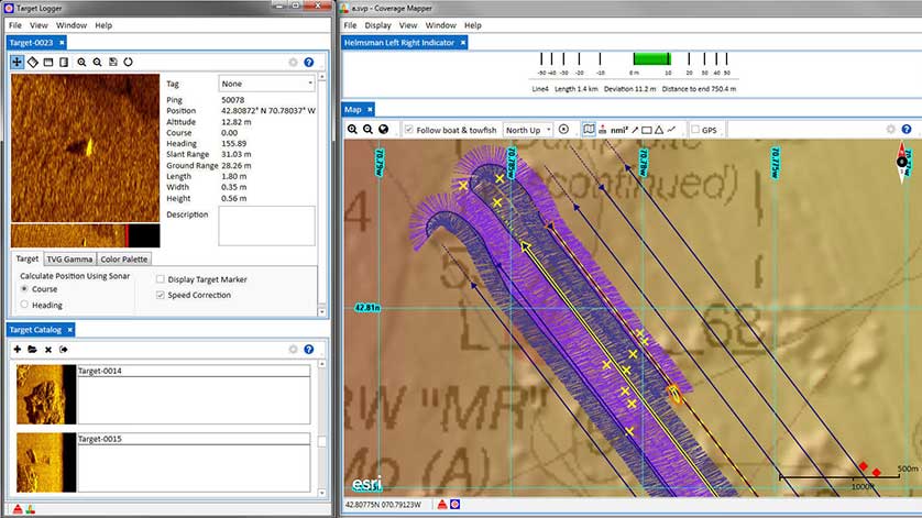
EdgeTech, a leader in high resolution sonar imaging systems and underwater technology, has released a new version of its well-known Discover sonar software. The new software coverage mapper module has advanced navigation features allowing the setup of survey lines with a left/right steering indicator to assist in survey line control.
Background navigation charts and other imagery such as multibeam bathymetry and satellite imagery can be layered or blended with individual transparency control, a feature unique to this software. Coverage mapper supports unencrypted S-57 Electronic Navigational Charts (ENCs), BSB3 Raster charts as well as standard Geo-TIFF imagery. Real-time survey track lines of both the survey vessel and towfish are displayed along with side scan sonar swath coverage to ensure that proper overlap is maintained during survey operations.
In addition, the new Target Logger module has simplified the process of analyzing and measuring targets of interest. Measurements are performed with simple cursor click and drag. Advanced manual altitude tracking is a feature that helps with noisy data where auto tracking may have difficulties. This feature ensures the accurate measurement of target height above the seafloor. Targets are catalogued and can be exported as a Target Report with target images and all-important information such as measurements, position, etc.
The new coverage mapper and target logger software comes with all new side scan sonar systems such as the 4125 ultra-high resolution lightweight portable system and the 4200 multi-purpose survey system.
Customers using EdgeTech sonars can download the Discover software at no charge from the company’s website or by contacting the company directly.