Smart Sea Gliders Improve Ocean Observation and Ocean Prediction
Daniel Parry
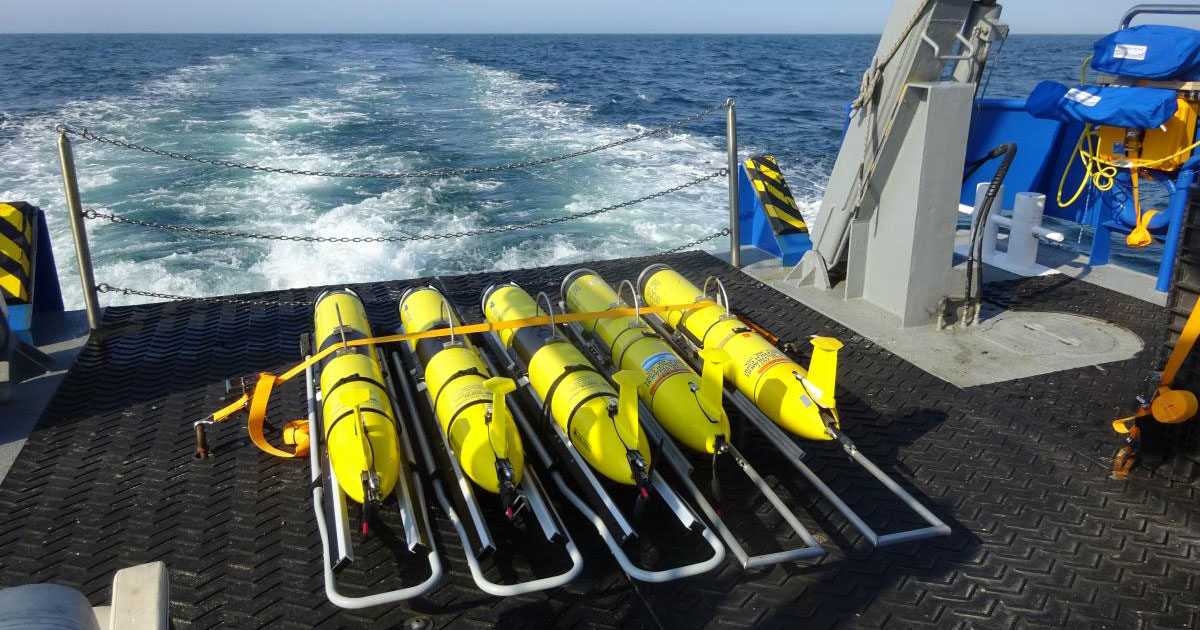
The US Navy maintains a large fleet of ocean gliders for environmental measurements. Ocean glider are slow-moving, long-endurance, underwater vehicles that gather data as they travel through the ocean’s interior using high-efficiency buoyancy engines. (US Naval Research Laboratory)
Scientists from the U.S. Naval Research Laboratory’s Ocean Sciences Division are optimizing the placement of ocean gliders and the usage of glider data to improve the Navy’s ability to predict ocean conditions.
Researchers frequently use gliders – slow-moving, long-endurance underwater vehicles – to collect data on ocean conditions such as temperature, depth, and salinity; in effect, observing the ocean’s weather.
“Predicting the ocean’s interior weather is challenging, yet it has important implications for all those who sail and operate on its waters,” said Jeffrey Book, Ph.D., an NRL oceanographer. “To help mitigate this problem, the ocean observing community has been developing new techniques for autonomously measuring the ocean’s interior and reporting data back in real time.”
Because of the ocean’s vast volume, efficiently placing a relatively small number of gliders to capture observations of a dynamic environment can be tricky.
Recently, NRL researchers have been looking at ways to optimize glider placement, including using them in teams.
 The benefit of teams
The current paradigm in deploying ocean gliders calls for placing them far away from each other to maximize their limited spatial coverage.
However, Book said a slowly moving, single glider by itself cannot tell the difference between a stationary, kilometers-long ocean feature and a traveling ocean feature that oscillates over several hours. On the other hand, a team of gliders working together can provide spatial context and potentially help resolve this issue.
Placing gliders in teams required a change in piloting techniques, adding complexity to the project. To enable piloting gliders together, researchers built on an existing automated piloting tool developed by NRL called Guidance for Heterogeneous Observation Systems or GHOST.
GHOST had the ability to optimize single glider use with user-defined conditions. For example, users could specify ocean areas to avoid and GHOST would provide reasonable paths under these restrictions.
Book and the research team adjusted GHOST to employ glider teams by adding two rules.
“The first rule was gliders should not be too close together, because current models can’t use data collected too close to each other,” said Charlie Barron, Ph.D., head of NRL’s Ocean Data Assimilation and Probabilistic Prediction group. “The second rule was they shouldn’t be too far apart. This is because an individual glider moves too slowly to correctly identify and measure most major ocean features, and a team of gliders is needed to provide enough data for the model to correctly initialize features such as eddies, filaments, and fronts.”
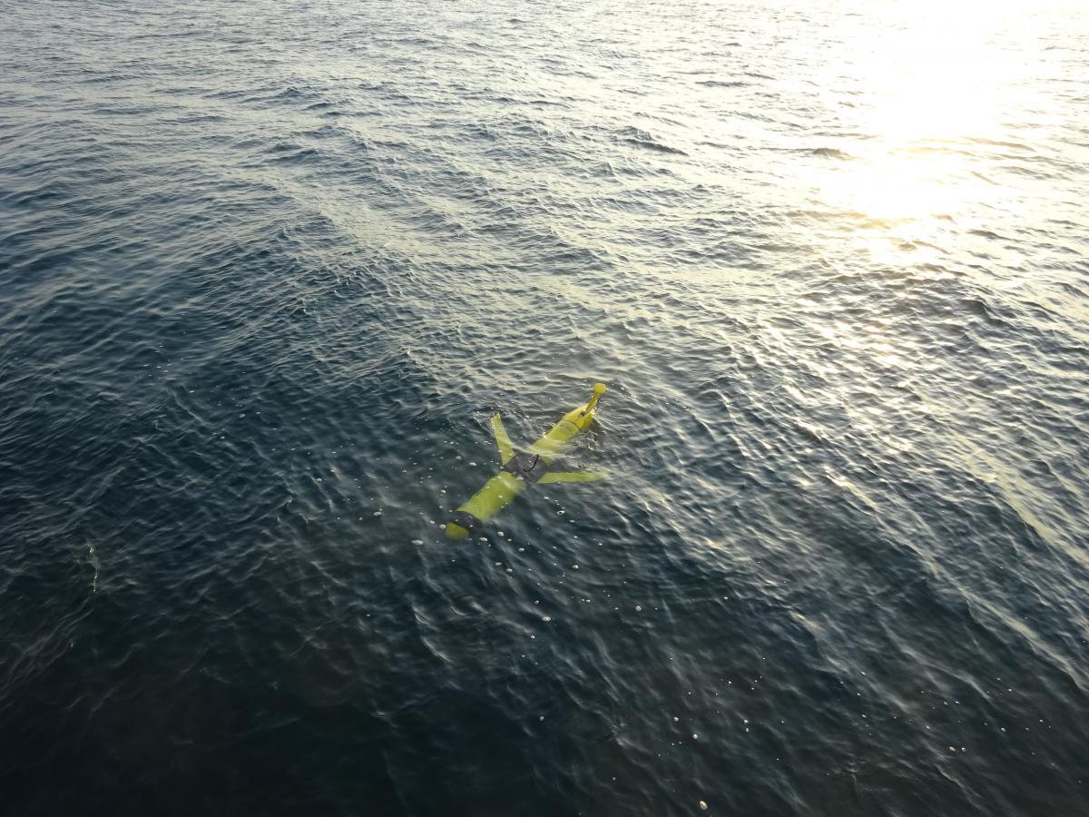 Ocean gliders are one of the Navy’s many tools for collecting data on the internal structure of the ocean for assimilation into ocean models. Gliders surface periodically to transmit data via satellite are capable of collecting numerous types of data, including currents, temperature, salinity, pressure and optics. (US Naval Research Laboratory)
Taking glider teams into the field, but where?
With GHOST upgraded, Book and the team took to the field to test the teaming concept.
A first big decision was location, and the team decided to go to North Carolina.
"Because of the complicated ocean circulation in the area, it’s an interesting place to test our ability to observe and predict the ocean environment,” Book said. "The warm transport of tropical water northeastward along the continental shelf break by the Gulf Stream current creates some complex structures."
Book explained the additional dynamic of how some Gulf Stream water spins off the main stream onto the shelf where it can sink below coastal water. Even though Gulf Stream water is warmer, its salinity makes it denser than the fresher but colder shelf water. Ocean gliders provide vital measurements in these conditions because the colder waters above mask the warmer waters below.
Finding and predicting such features can be important to many different types of naval operations.
In this example, the warm salty waters create a subsurface pocket with very different acoustic properties, which can create acoustic shadows.
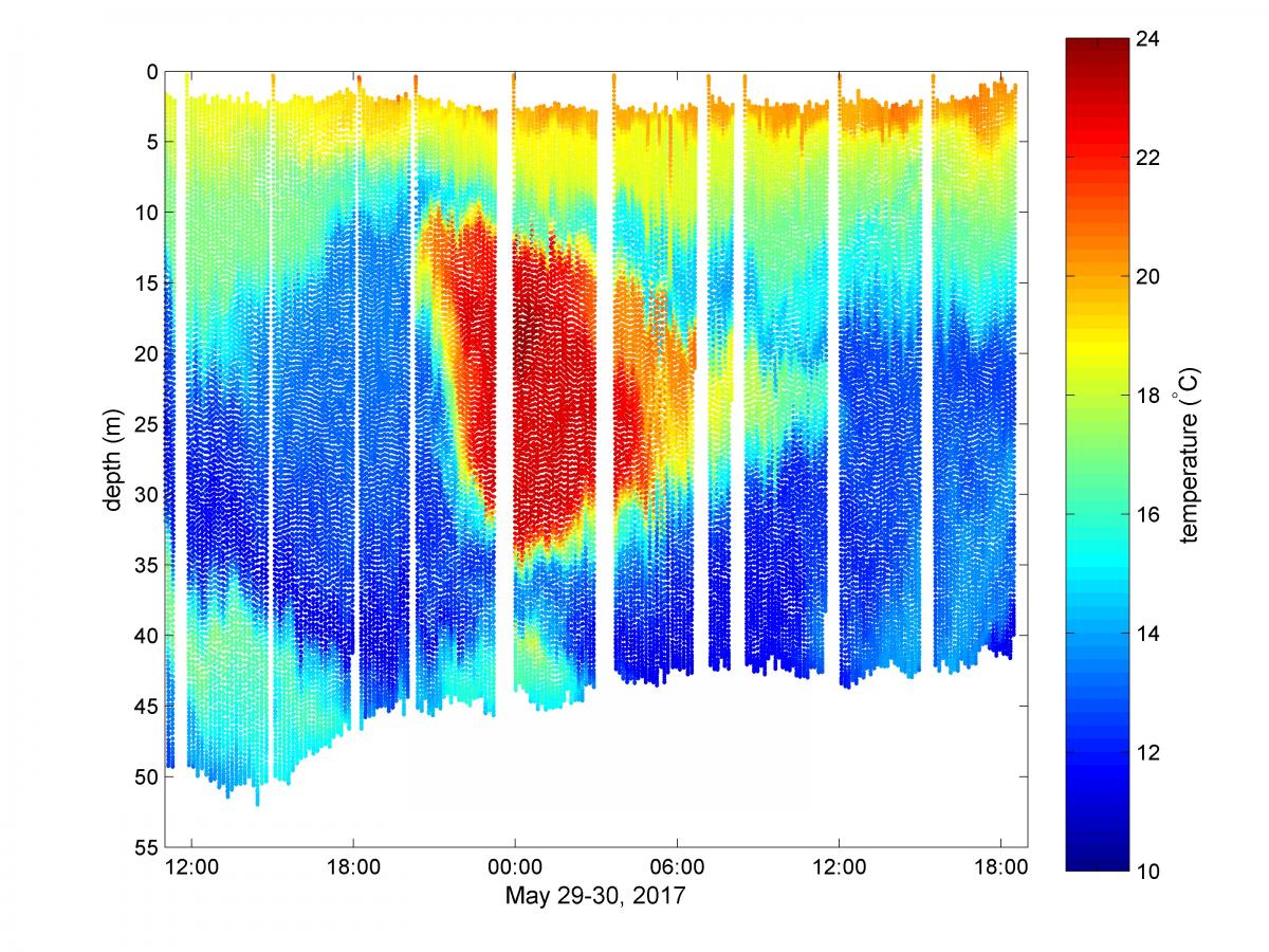 Red colors show a warm and salty pocket of submerged Gulf Stream water on the North Carolina shelf as measured by an NRL glider on May 29-30, 2017. The dots, which make up the graph composite are individual temperature measurements taken as the glider descends and climbs in depth. The gaps in measurement occur when the glider is on the surface transmitting recent measurements back to Stennis Space Center for use in correcting the forecast model for this region. (US Naval Research Laboratory)
Grading the glider teams
For 18 days off the coast of North Carolina, NRL researchers tested six gliders in different team configurations near the Gulf Stream.
Overall, the gliders collected more than 13,000 conductivity, temperature and depth profiles used in two ocean forecast models.
Because of the volume of closely spaced glider data collected, Book’s team also created and tested new ways to use the data in ocean forecast models. Prior assumptions based on the idea of single gliders collecting data far apart from each other had to be relaxed or removed before the models could begin to use glider team data effectively.
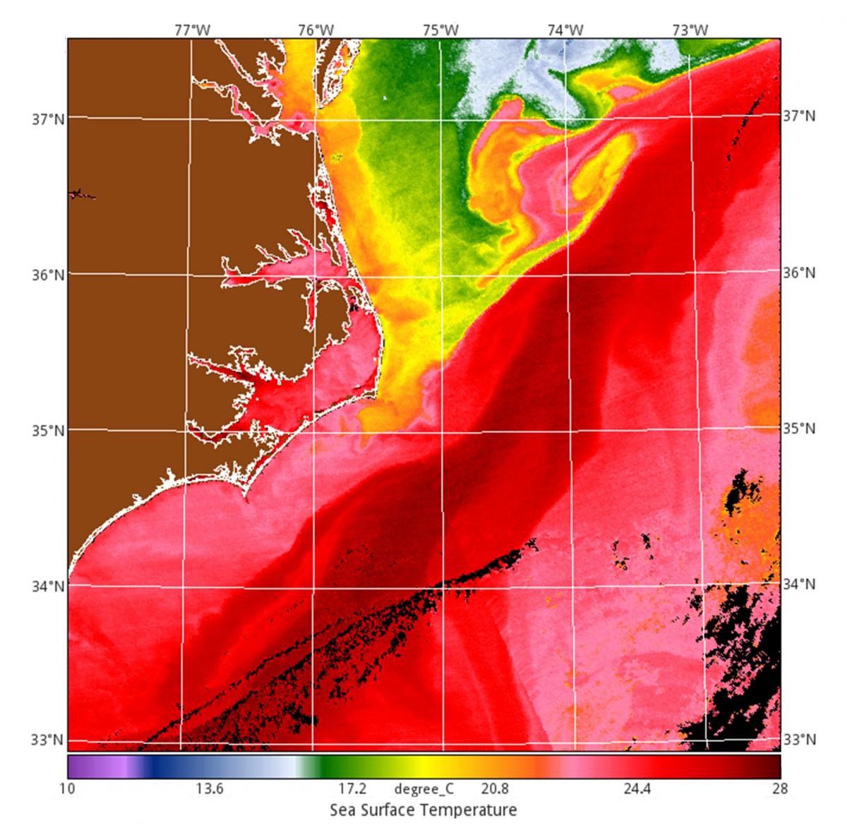 Satellite measured sea-surface temperature offshore North Carolina at the start of the NRL experiment. The deep red colors (28ºC/82ºF) mark the location of the Gulf Stream, while the yellow and green boundaries mark out swirling eddies and filaments that move Gulf Stream waters and cooler coastal surface waters around. Black streaks are clouds that block the satellite measurements. (US Naval Research Laboratory)
“We found that there is little to no benefit in using teams without improving the way you assimilate the data,” said Book. “There was some benefit to just improving the assimilation method for the models, but this benefit was greatly increased if we used glider teams instead of single gliders. What we saw overall was that it is important to do both.” The overall improvement Book’s team observed was 9 to 12 percent, a measurement of improved accuracy of the ocean weather models.
This effort was completed through base program funding provided by the Office of Naval Research in collaboration with the National Science Foundation. The intense level of field effort was made possible by a team of 12 researchers and technicians from NRL’s Ocean Sciences Division, two reservists from the ONR Reserve Component program for support on meteorology and oceanography related projects, as well as collaborative help from a postdoctoral scientist, technicians, and students representing five separate academic institutions.
By Daniel Parry, NRL Corporate Communications