Enormous Caribbean Waves Before 1492
Ocean News
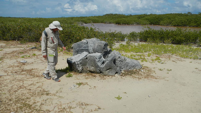
A brain coral boulder eight feet in diameter stands 750 feet inland in the British Virgin Islands. Geologists say that the coral was brought ashore, probably alive, by an unusual tsunami or storm between the years 1200 and 1480.(Credit: Brian F. Atwater, U.S. Geological Survey. Public domain.)
Geologists have discovered evidence that unusual seas detached living corals from a Caribbean reef and scattered them far inland, as boulders, during the last centuries before Columbus arrived. The new findings will reinforce precautions against coastal hazards, Caribbean tsunami specialists said.
The coral boulders were found in the British Virgin Islands at Anegada—a low-lying island named by Columbus in 1493 and located behind a coral reef that faces the Puerto Rico Trench. One of the geologists, Brian Atwater of the U.S. Geological Survey said, “We were astonished to find over 200 coral boulders scattered as much as one-third of a mile inland from the island’s trenchward shore.” He added, “Some are entire colonies of brain coral a few feet in diameter. All were likely emplaced during a sea flood sometime between the years 1200 and 1480.”
The geologists blame either a rare tsunami or an unusual hurricane. They point to dormant tsunami sources in the Puerto Rico Trench, where tectonic plates meet 100 miles north of Puerto Rico and the Virgin Islands. But they also note that a tropical cyclone can produce tsunami-like surges, as happened in the Philippines in 2013.
The findings on Anegada bring scientists a step closer to discovering whether faults in the Puerto Rico Trench produce large earthquakes and associated tsunamis. Tsunamis generated along smaller faults took lives in the Virgin Islands in 1867 and in Puerto Rico in 1918. No tsunami from the trench itself is known from written records going back to 1530.
Sharleen DaBreo, the Director of the Department of Disaster Management in the British Virgin Islands, said the findings support the BVI’s public education and outreach efforts. She said that with regards to the possibility of a Puerto Rico Trench tsunami, “The more evidence we have of tsunamis in the region, the easier it will be to boost public awareness. As it stands, Caribbean tsunamis are so rare that some people may downplay tsunami hazards, even on low-lying shores that face the Puerto Rico Trench.”
For Elizabeth Vanacore of the Puerto Rico Seismic Network, the findings serve as a reminder to use a felt earthquake as a timely cue to evacuate coastal areas. “A tsunami generated during an earthquake in the Puerto Rico Trench would reach our nearest shores in less than 30 minutes,” Dr. Vanacore said, “For many years we have advised people along the coast to respond immediately upon feeling a strong or long-lasting earthquake, by going to high ground or at least inland.”
Christa von Hillebrandt-Andrade, who leads the Caribbean Tsunami Warning Program of the National Oceanic and Atmospheric Administration, added that a Puerto Rico Trench tsunami could spread into much of the Caribbean and could reach the U.S. Atlantic seaboard as well. “Tsunami warning centers are continuously monitoring earthquakes throughout the Caribbean,” she said. “The centers would alert government officials and the public in the case of any tsunami event.”
The geologists compared the coral boulders of 1200 to 1480 with traces of other unusual seas at Anegada, including modern hurricanes up to category 4, and a tsunami that crossed the Atlantic in 1755. They concluded that whether from tsunami or storm, the waves that deposited those corals far outran any others at Anegada in the past 2,000 years or more.
Ms. von Hillebrandt-Andrade related this extended history to a recent lesson from Japan. “When anticipating natural hazards,” she said, “it’s important to know what happened many centuries into the past. The 2011 tsunami was probably bigger than any other Japanese tsunami since the year 869.”
The research paper, “Extreme waves in the British Virgin Islands during the last centuries before 1500 CE,” was published today in Geosphere, a peer-reviewed journal of the Geological Society of America. The paper contains 45 pages of color photographs and maps. It is available online without charge.