dot.Ocean’s Unmanned Survey Platform (USP) Calypso
Ocean News
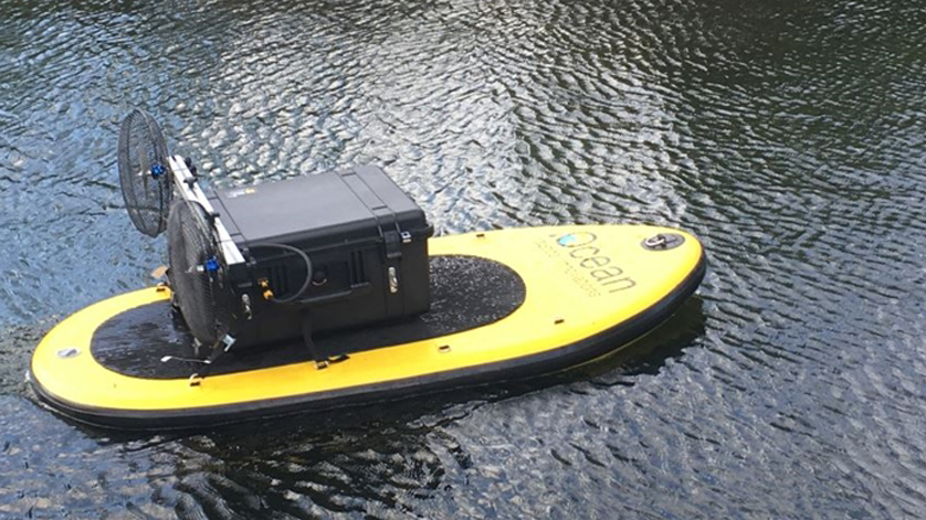
The Unmanned Survey Platform (USP) Calypso is an inflatable, remote controlled drone that can carry a wide range of sensors for hydrographic and environmental surveys. The USP is easy to transport and can be installed and operated by one person. Only a Peli Case and a backpack are foreseen for transport.
Calypso is a platform for single beam echo sounder measurements, but various other types of sensors can be mounted on the platform as well, like a camera, light, gas sensor, temperature sensor, ADCP or water sampler.
Specifications:
- Length: 1.80m
- Beam: 0.80m
- Draft: 0.10m
- Weight: 20kg
- Payload: 25kg
- Propulsion: 2 x DC electric rotors
- Speed: max 6 knots
- Endurance: 2 hours
- Control: radio control
Communication
Calypso is connected via the cellular network to the cloud platform Atlantis. In general 3G or 4G services are used. Data services are adapted to the link quality. In case of an stable data link, data is streamed real-time to Atlantis for data processing and visualization. At remote locations, where no internet connection is available, the data can be stored locally. When back in range of internet connection, the data can be pushed towards Atlantis.
Atlantis
All data is collected in dotOcean's software platform, Atlantis, is a big data acquisition system with a user friendly web based visualization tool.
The platform provides an online interface to visualize the captured data real-time. Atlantis is an online data storage platform where all sensor data is acquired and stored in an online database. The data can be combined with survey data from all kinds of hydrographical equipment. Lastly, the data processing software is capable to acquire, receive, process, display, do quality control and distribute data to the web server for visualization purposes.