CSA Ocean Sciences’ Maps Published in Water Atlas
Ocean News
CSA Ocean Sciences Inc. (CSA), a marine environmental consulting firm specializing in spatial data collection, analysis, and management, is featured in Water: An Atlas, a map collection published by the non-profit group Guerilla Cartography.
![]() The group uses cartography and collaboration to tell stories about global issues. Water: An Atlas can be viewed online here.
The group uses cartography and collaboration to tell stories about global issues. Water: An Atlas can be viewed online here.
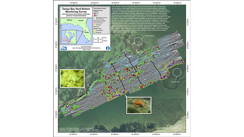
Two maps in the Atlas are contributions from the CSA Environmental Data and Geospatial Services (EDGS) team, highlighting recent projects in the marine environment: Tampa Bay Hard Bottom Monitoring (Feature 72) and Oil and Gas Environmental Monitoring Offshore Gabon, West Africa (Feature 156).
CSA’s EDGS team integrates Geographic Information System (GIS) tools and techniques in nearly every project we conduct. From data-rich maps to a web-based environmental Common Operating Picture (eCOP), our EDGS products are fundamental to the environmental services we provide clients in the United States and internationally.
“We got involved in this non-profit effort to share stories of how we, as GIS analysts, use spatial data for projects in the marine environment, particularly those involving mapping of resources and monitoring of potential impacts,” said CSA’s Dustin Myers. “We’re pleased that our work is included among the stories told in the atlas.”
Learn more about the non-profit Guerilla Cartography.
National Geographic also featured a story on the atlas and contributors, which can be read here.
CSA’s expertise in coastal, marine, and deep ocean surveys is built on the integration of science, operations, and an understanding of environmental data collection, management, and analysis within geospatial domains. For more information on CSA’s range of marine environmental consulting services, click here.