Below-Average ‘Dead Zone’ Measured in Gulf of Mexico
Ocean News
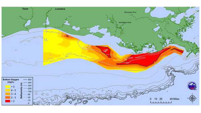
At 2,720 square miles, an area about the size of Delaware, this year's dead zone in the Gulf of Mexico is smaller than average. The map shows the distribution of bottom-water dissolved oxygen taken during a research cruise from July 24 to 28. (Courtesy of N. Rabalais, LSU/LUMCON & R. Turner, LSU)
NOAA-supported scientists have determined that this year’s Gulf of Mexico “dead zone”— an area of low oxygen that can kill fish and marine life — is approximately 2,720 square miles (7,040 square kilometers), an area about the size of Delaware. This summer’s dead zone size is the fourth smallest area mapped since 1985 and is smaller than the 5,780 square miles forecast by NOAA in June.
The effort to determine the size of the dead zone was led by scientists at Louisiana State University and the Louisiana Universities Marine Consortium during a research cruise from July 24 to 28 aboard the R/V Pelican.
“Persistent winds from the west and northwest in the few weeks preceding the cruise likely pushed the low oxygen water mass to the east and piled it towards the central shelf and towards Grand Isle. Additional winds and waves at the beginning of the cruise in the area to the immediate west of the Mississippi River delta to the area off Barataria Pass, likely mixed oxygen into these shallower waters and reduced the hypoxia,” said Nancy Rabalais, Ph.D., professor at LSU and LUMCON, who led the survey mission. “This resulted in an unexpectedly small dead zone, though similar conditions and smaller areas of bottom-water hypoxia were documented in 1998 and 2009.”
The annual hypoxia forecast uses nutrient runoff data from the U.S. Geological Survey in a suite of well-tested models developed by NOAA and its partners over the past decade. The models have helped validate the significant role that Mississippi River nutrient runoff plays in determining the onset and size of the dead zone during the summer, and helps set nutrient reduction targets.
Nutrients determine the potential size of the zone while weather events and currents dictate the actual size and location. The hypoxic zone changes through the summer and if reduced during storm events and strong winds, as seen this year, the zone usually returns to the full potential within a couple of weeks. Continued monitoring is important in our understanding of how ocean conditions influence the zone size.
“The data collected from this annual, long-term research program is critical to our understanding of a wide range of Gulf issues including hypoxia and beyond,” said Steven Thur, Ph.D., director of NOAA’s National Centers for Coastal Ocean Science. “Not only is measuring the size of the Gulf of Mexico dead zone vital to informing the best strategy to reduce its size, but also to reduce its impacts on the sustainability and productivity of our coastal resources and economy.”
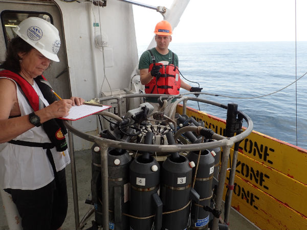 Scientists from LUMCON and NOAA collect oxygen measurements to determine the size of this year's dead zone, an area of low oxygen that can kill fish and marine life. This cruise has been performed since 1985, creating an important long term data set for scientists. (NOAA)
These nutrients stimulate massive algal growth that eventually dies, sinks and decomposes, and in the process uses up the oxygen needed to support life in the Gulf. This loss of oxygen in bottom waters will render the habitat unusable and force species to move to other areas to survive. Non-lethal impacts have also been found to reduce the reproductive capabilities of some fish species and slow shrimp growth, leading to reductions in the average size of shrimp caught.
The five-year average of the monitoring cruises remains larger than the 1,900-square-mile size set by the Interagency Mississippi River Watershed Nutrient Task Force in 2001. The largest dead zone measured in the Gulf, 8,776 square miles, occurred in 2017. This average helps account for only having a single measurement that may not capture the maximum size, as the cruise is only a snapshot of the dynamic hypoxic zone.
This is the sole metric used by the Gulf of Mexico/Mississippi River Watershed Nutrient Taskforce to determine whether efforts to reduce nutrients in the Mississippi River, primarily from developed land and agricultural runoff continue to affect the nation’s coastal resources and habitats in the Gulf.
New initiatives such as the Runoff Risk Forecast are reaching new states and are designed to help farmers apply fertilizer at optimum times to ensure it stays on fields and nutrient runoff to the Gulf is limited.
NOAA continues to fund monitoring and research efforts to understand the dead zone as well as to study the impacts of hypoxia on fish and fisheries in the Gulf of Mexico through its Northern Gulf of Mexico Ecosystems and Hypoxia Assessment program, known as NGOMEX.
LUMCON’s Gulf Hypoxia website has additional graphics and information about this summer’s research mission as well as missions in previous years.