High-Tech “Smart Boulders” Give the First Look from Inside an Underwater Landslide
Raúl Nava
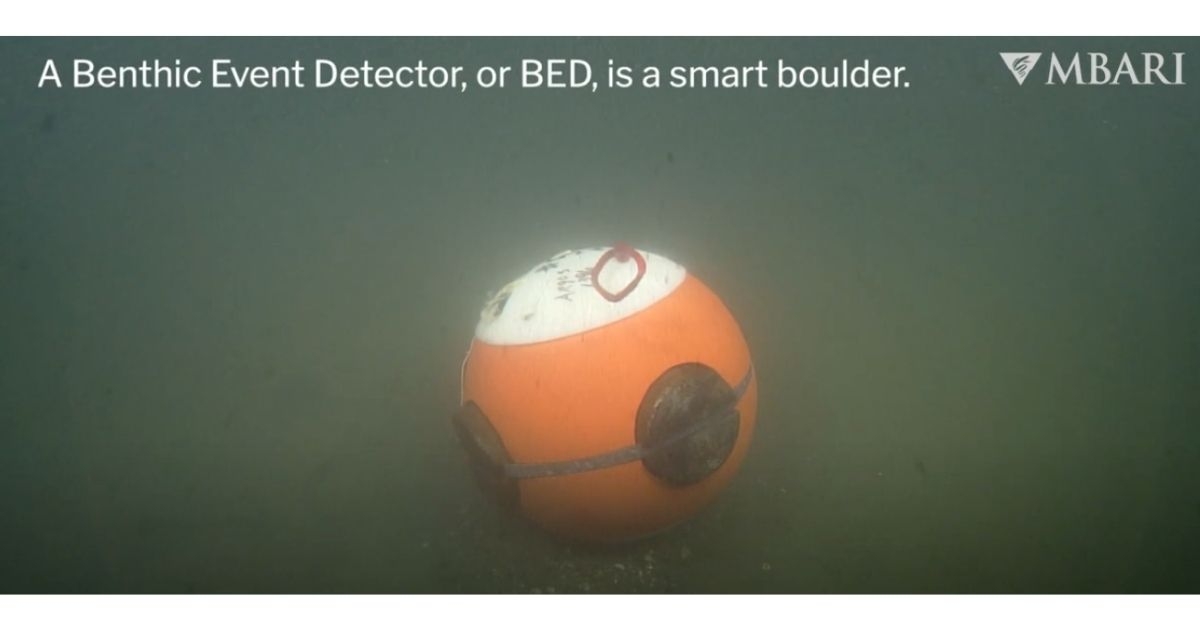
Image credit: ©MBARI
The sediment that pours out of coastal rivers accumulates at the head of Monterey Canyon.
Periodically, it collapses and forms a sediment gravity flow that surges through the submarine canyon like an underwater landslide. Because these flows move quickly and powerfully along the seafloor, they are challenging for scientists to study. Motion-sensing “smart boulders” developed by MBARI engineers have provided the first detailed look inside sediment gravity flows.
Benthic Event Detectors (BEDs) ride the moving sediment and log data as they travel within the flow. Data from BEDs deployed in Monterey Canyon reveal sediment gravity flows mobilize the top three meters (10 feet) of the seafloor, with major implications for underwater infrastructure.
“These sediment gravity flows aren’t currents that move along the seafloor, they’re currents that involve the seafloor. They’re very powerful and can put civil infrastructure, like data cables, at risk,” said Roberto Gwiazda, a geologist at MBARI and lead author of a study published earlier this year in JGR Earth Surface that detailed findings from the deployment of BEDs in Monterey Canyon.
Cliff retreat, the Salinas River, and smaller coastal rivers draining into and to the north of the bay all deposit coarse sediment in Monterey Bay. Coastal currents carry this sediment until it becomes trapped at the head of Monterey Canyon. It accumulates at the canyon’s head until a gravity flow event transports it downstream. Storms, waves, tides, earthquakes, or simply accumulated mass can trigger a slope failure at the canyon’s head and create a landslide that barrels down the twists and turns of Monterey Canyon. These density-driven events link land to the ocean’s depths, moving sand from land to the abyssal plain.
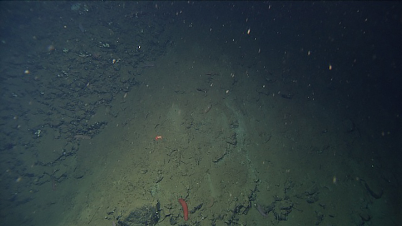 Powerful and unpredictable sediment gravity flows barrel down Monterey Canyon with dramatic impacts on the community of life on the seafloor. These underwater landslides also threaten critical infrastructure on the seafloor. Image ©MBARI
Because these flows are energetic, episodic, unpredictable, and occur in relatively inaccessible environments, it has been challenging to document them in detail. Their velocity, the amount of sediment they carry, the thickness and internal structure of the flow, and the flow’s distance and duration remain unclear.
These currents are powerful—previous research in Monterey Canyon clocked them at velocities up to seven meters per second (15 miles per hour)—and easily overwhelm traditional research instrumentation. Acoustic instruments cannot penetrate to the deepest part of the flow and the force of the moving sediments easily damages equipment placed on the seafloor.
MBARI engineers designed the rough-and-tumble BEDs to measure the near-seafloor conditions inside a sediment gravity flow. These boulder-like instruments rest on the seafloor and contain a package of motion-sensing instruments. They were engineered to replicate the behavior of boulders in sediment gravity flows, while collecting information about their own motion. These rugged devices can collect data within the densest part of a sediment gravity flow, where most of the mass is being carried. Buried BEDs have an acoustic homing beacon so they can be recovered by one of MBARI’s remotely operated vehicles or an autonomous vehicle, such as a Wave Glider, can wirelessly download the data.
The Coordinated Canyon Experiment—an ambitious project organized by MBARI Senior Scientist Charlie Paull with an international team of geologists—leveraged a suite of sophisticated instruments, including BEDs, to provide a detailed and comprehensive view of sediment movement within Monterey Canyon. The experiment monitored sediment gravity flows across a distance of approximately 50 kilometers (31 miles). From 2016 to 2017, MBARI researchers deployed 11 BEDs on the canyon floor, using the remotely operated vehicle (ROV) Ventana to place them at 200, 300, and 400 meters (660, 980, and 1,300 feet) deep. The BEDs were deployed for an 18-month period and recorded data from 10 sediment gravity flows.
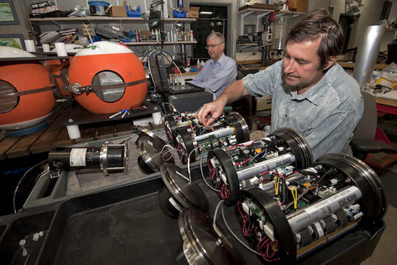 MBARI engineers Bob Herlien (left, now retired) and Denis Klimow (right) assemble BED spheres and other equipment for experiments to better understand the flow of sediments in Monterey Canyon. Image: Todd Walsh ©MBARI
“This is the first time conditions have been continuously monitored within sediment gravity flows as they barrel down the canyon,” explained Gwiazda. “The unique synergy of science and engineering at MBARI produced innovative instrumentation that can withstand the power of the flowing sediments. MBARI scientists identified what sensors were needed to track a sediment flow, MBARI engineers then developed novel instrumentation, and MBARI computer engineers were able to develop software to visualize the motion of the BEDs as they travel within the flow.”
The sediment flows are estimated to be at least four meters (13 feet) thick. Based on the type of motion the BEDs experienced while being transported in a gravity flow, researchers have determined that these flows do not travel on top of the seafloor. Instead, they churn up the upper two to three meters (six to 10 feet) of sediment as they move several kilometers down the canyon.
Data from the BEDs also helped researchers document the internal dynamics of sediment gravity flows. Through the instrument rotation, researchers were able to reconstruct and visualize the density structure of the flow.
Previous work from the Coordinated Canyon Experiment concluded that sediment gravity flows in Monterey Canyon contained a dense basal layer traveling along the ocean floor ahead of a slower bottom water current carrying a suspended sediment load. This recent study has confirmed that the flow front consists of a very dense, slow-moving layer overridden by a fast-moving, less dense layer. The seafloor layer is not a uniform sediment slab with well-defined upper and lower boundaries, but rather is a fluid layer of varying thickness that accommodates changes in velocity caused by a variable seafloor terrain.
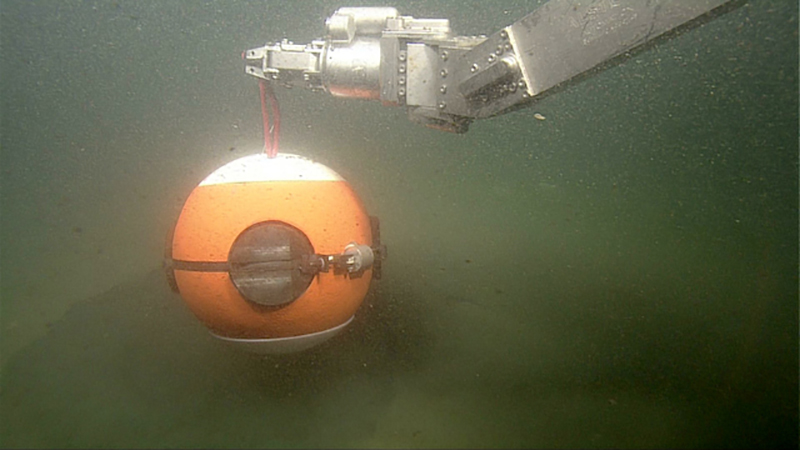 By using the boulder-like Benthic Event Detectors (BEDs), MBARI researchers were able to record data from inside the powerful sediment gravity flows that stream down the twist and turns of Monterey Canyon. Image ©MBARI
“To me as a scientist, it’s fascinating to study these processes that we know nothing about. Who knew the seafloor would be mobilized three meters deep across several kilometers?” said Gwiazda. “During these events, everything is wiped out—all of the biological community that exists on the seafloor gets wiped out. It’s a dynamic environment from a biology and geology perspective.”
Understanding the nature of sediment gravity flows is also important for evaluating whether they constitute a threat to infrastructure that rests on the seafloor, including cables for data and power or pipelines for oil and gas.
Seabed cable networks carry over 95 percent of global data traffic. The eruption of the Hunga Tonga–Hunga Ha‘apai volcano in January 2022 disrupted communications with Tonga and demonstrated the fragility of civil infrastructure against powerful marine geological disturbances. Gwiazda cautions powerful sediment gravity flows in coastal submarine canyons may be a similar geohazard.
Article by Raúl Nava