The Lost 52 Project: Bringing History Back to Life
Tim Taylor
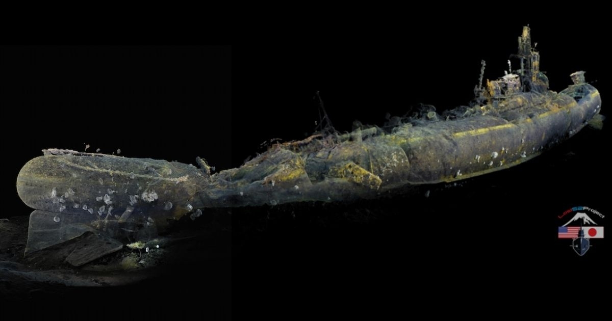
The stern section of the USS Grunion—starboard view. (Image credit: Lost 52 Project)
The suggestion that we know more about the lunar surface than what lies beneath our oceans is something of a cliché these days. It is also somewhat of an unfair assertion. Throughout history, civilizations have gazed upon the moon in wonderment and curiosity, mesmerized by its phases and cratered appearance.
When attentions turned to the oceans, however, people were mostly presented with a featureless expanse of waves and weather—a place where sealife dwelled and monsters laid in wait. The small glimpses our ancestors had into the unknown depths became a rich source of legend and myth.
Today, this is no longer the case because over time our collective imagination became piqued by what really was beneath the waterline. This imagination has led us to successfully engineer highly advanced subsea technology, and within the next few decades we and various stakeholders from the ocean industries will be able to map the oceans that, unlike the moon, have eluded past generations.
IN SEARCH OF HISTORY
The Lost 52 Project is one such initiative that is already charting previously unexplored areas of the planet’s seabed. Utilizing advanced deep-water autonomous underwater vehicles (AUVs), the Project has set out in search of archeological knowledge and understanding. World War II, although only 75 years ago, is accountable for more underwater historical wreck sites than any other time in human history, and the Lost 52 Project has set its goal to discover and document the 52 US submarines lost in battle.
To date, we have made numerous discoveries. These sites are the final resting place of 288 sailors. This is a monumental task and a search that, admittedly, may never be fully accomplished. That said, the search is the key. The ability to cover ground and put in the time is often a thankless task. Typically, when conducting commercial underwater surveys, the goal is to collect detailed coverage of an area; in our case, we are looking for relics of warfare.
AUV DEPLOYMENT
For this project, we are deploying AUV systems equipped with synthetic aperture sonar and magnetometers enabling us to efficiently and effectively collect high-quality scans with 120% coverage. Generally speaking, collecting data is a simple process of filling in the designated search boxes in a consistent and methodical process and dealing with mechanical, equipment, and environmental obstacles as part of the process. The Lost 52 expeditions operate under the same process but more often than not, based on our research and 75-year-old data sets, we are tasked with searching a large area with insufficient time to cover the entire site. This creates a new dynamic for our entire team.
In preparation, our research is compiled into a master book that is printed and distributed to the team of archeologists, AUV technicians, and merchant marines. Each day we add new survey set data as the crew negotiate the local conditions, currents, weather that the fallen sailors experienced 75 years ago. This in situ connection with the past is an intangible but very real part of our exploration. Every day presents the challenge of selecting our next search area, knowing full well that our time and coverage may be limited. There is always the chance we may miss our target by a mere 50 meters, like we almost did when we discovered the USS Grayback, off Okinawa.
CREATING 4D REALITIES
Filming our discoveries is an obvious next step. The project aims to do more than just capture an image; we want to generate the most comprehensive image scan possible to enable us to create a 4D immersive experience. From the start, it was not enough to just locate these lost submarines; we had to document and share their story with the world. It was important to apply the latest technology, but we still had to deal with budgets, lead times, and priorities. Access to the latest technology is often cost prohibitive, and in our case, LiDAR was not a viable option. This led us to seek out and deploy the developing technology of underwater photogrammetry.
With navigation, accuracy is always an issue, and the collection of underwater data for 4D image creation has it challenges. It should be noted 3D data is what we are collecting using our sonar and multibeam payloads. Creating images using authentic video, as well as still images, allows us to add the 4th element of true in situ color, unlocking a truly 4-dimensional representation of the wreck that can be manipulated, studied, and explored. The added ability of utilizing our current ROV HD cameras with no additional equipment requirements is a game-changer.
Reconstructing virtual 4D images of these submarine sites as they sit today, provides us with stunning and detailed data sets to virtually explore these sites for years to come. Not only does this enhance our educational STREAM (Science-Technology-Robotics-Art-Mathematics) programs, but it will also pay homage to the brave Navy Submariners of WWII. Modern-day technology is transforming how we see the underwater world. Just like with the moon, seeing will lead to knowing, and knowing will lead to wisdom.
This technology, in large part, was historically pursued to enhance defense and military capabilities. Ironically, this very same technology is now being used to explore and enhance our understanding of the world. Maybe if it was the other way around, we would be treading forward with greater wisdom. Ultimately our greatest test will be whether we have the ability to use that wisdom to harmoniously inhabit and sustain this planet. Until then, it should be mandated that those who seek exploration and understanding of our marine environments leverage breakthrough technology to tell the stories of what lies beneath.
To learn more about Tiburon Subsea Research, visit: https://www.tiburonsubsea.com
For more information about the Lost 52 Project, visit: http://www.lost52project.org
This story was originally featured in the digital issue of ON&T April 2021. Click here to read more.