AROWIND PROJECT: An Autonomous Inspection Solution for Offshore Wind That Drastically Reduces Costs, Risk, and Emissions
Chris Gilson
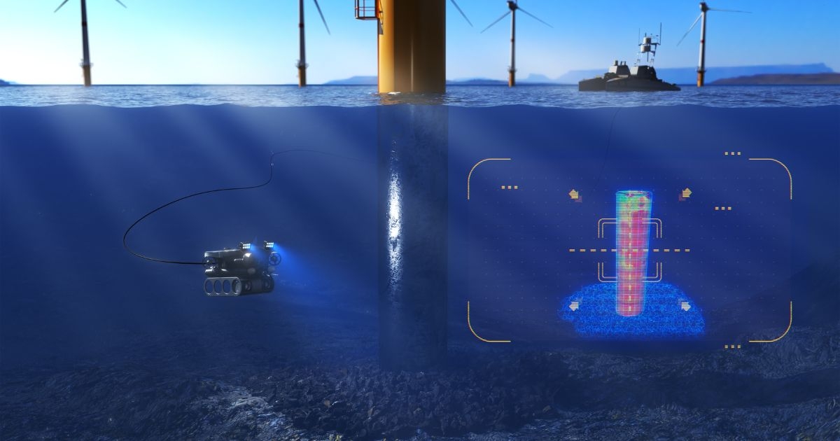
Illustration created for the AROWIND project, shows the Voyis’ laser scanner collecting data in real time of the inspected offshore windfarm. (Image credit: Voyis)
The ocean sector is rapidly evolving as green energy demand fuels incredible growth in offshore wind. It is becoming evident that the technologies and methodologies historically used in the offshore industry to monitor and maintain assets must also evolve to address new inspection challenges and tighter cost constraints.
Moreover, a global pandemic has catalyzed survey operators to begin adopting approaches that enable remote operations and reduce reliance on human factors. Together these trends will drive radical innovation in autonomy and platform miniaturization that has the potential to drastically reduce the operational costs associated with subsea survey.
These changes are paramount in the manner offshore wind operators will need to manage their subsea assets, which are projected to grow ten-fold over the next decade and require the annual inspection of up to 60,000 wind turbines. With 25-30% of lifecycle costs spent on operation and maintenance, it is unacceptable that 70% of this is currently allocated to vessel charters alone. Operators desperately seek innovative methods to achieve low-cost shore-based operations.
This paradigm shift is what inspired the AROWIND project—a technology demonstrator led by Voyis and funded by Canada's Ocean Supercluster, that will define a new standard for offshore windfarm inspection using a fully remote survey solution to reduce cost, carbon emissions, and human exposure.
BACKGROUND
The offshore wind industry has historically employed large work-class remotely operated vehicles (ROVs), deployed from expensive service operation vessels to complete general video inspection (GVI) of subsea assets, gaining only a qualitative risk assessment. Costly vessel charters and offshore personnel has driven high operation and maintenance (O&M) lifecycle costs, and a limited understanding of predictive failure models to drive preventive maintenance. The introduction of improved robotics solutions for qualitative measurements using new 3D optical sensors has seen some limited adoption, however, the use of large, crewed vessels continues to keep O&M costs stagnant.
The recent introduction of smaller commercial uncrewed surface vessels (USVs), from companies like HydroSurv, creates a new opportunity to address these challenges and improve offshore windfarm viability. Initial adoption of these USVs has been limited to surface-based hydrographic surveys, current modeling, and above water laser mapping, but this technology has only seen partial adoption for more complex offshore inspection tasks due to the inability to deploy ROVs.
The offshore wind inspection industry provides the perfect opportunity for adoption given the relatively close proximity to shore of wind farms, many less than 20 km (0-60 km) and shallow depths (<40 m), and the observational inspection scopes which can be accomplished with small platforms. A USV solution with a moderate endurance, paired with a capable small ROV and compact 3D sensors, would be able to address these inspection requirements from shore at a significantly lower cost.
PROJECT SCOPE
In February 2022, Canada’s Ocean Supercluster announced the launch of the Autonomous Remote Offshore Wind Inspection, Navigation and Deployment Project, also known as AROWIND. This $6.7 million project will be led by Voyis, a provider of subsea optical inspection technologies, and will seek to demonstrate a fully remote USV based inspection solution for offshore windfarms. As a technology demonstrator, the project will develop a range of new independent technologies that can be integrated into existing survey frameworks, while also proving their synergistic application as a complete solution for remote offshore wind inspection.
HydroSurv’s commercially available REAV USV platform will be the mobilization method for the project, expanding its current capability to autonomous deployment of the Deep Trekker Revolution ROV. This compact ROV simplifies the USV deployment challenges and will be essential in performing localized visual and quantifiable survey of subsea structures such as monopiles, foundations, cables, chains, and anodes. To address inspection requirements and drive qualitative preventative maintenance, Voyis’ 3D optical sensors (Insight Laser Scanners and Observer Cameras) will be miniatured and integrated with a Sonardyne navigation system to deliver both forward and downward survey capability. Enhanced with autonomous navigation, data analysis, and sensor aiding from EIVA, the solution will achieve operational viability.
INNOVATIVE TECHNOLOGY
Project AROWIND focuses on three areas of innovation: developing new capability for remotely controlled inspection and navigation, the miniaturization and performance enhancement of existing products, and the integration and optimization of existing technologies into a complete package for subsea windfarm inspection.
HydroSurv and DeepTrekker will collaboratively integrate the Revolution ROV onto the REAV USV, while developing a novel deployment system that autonomously and reliably deploys the ROV once the survey site is reached. Remote control technologies will initially be employed for manual shore-based control, and vehicle autonomy will be slowly introduced to reduce human interaction, in particular for automating survey trajectories.
Voyis’ Insight laser scanner and imaging systems will be miniaturized and integrated into a compact ROV skid for horizontal inspection scopes, such as foundation scouring, structural integrity, cable route mapping, and anode depletion modeling. In partnership with EIVA, the Observer camera will be extended into a forward-looking 3D modelling solution using EIVA VSLAM software. This package will enable vertical inspection scopes, such as corrosion modeling, marine growth mapping, chain/cable integrity, and structural as-built inspection, along with enabling autonomous vehicle piloting with navigational aiding. Machine learning software will be developed to improve the robustness of survey reporting, accurately evaluating the asset’s current conditions, without cumbersome manual analysis of point cloud data and stills images.
WIDER POTENTIAL
Looking forward, the emerging floating offshore wind segment is expected to increase significantly to nearly 10 GW of installed capacity by 2050, and will require additional subsea inspections with respect to mooring lines, anchors, floating cables, etc. This segment can be addressed with the same core technology deployed on larger platforms. But looking past offshore wind, AROWIND will have follow-on applications across the ocean sector.
Defense Mine Countermeasures is a sector that is actively investing in uncrewed autonomy and small ROVs, but without a commercial off-the-shelf (COTS) solution to achieve their vision of fully remote operations. The industry currently employs ROVs deployed from small human operated vessels, a practice which does not fully remove the operator from the high-risk minefield.
Many underwater civil infrastructure applications already employ small ROVs for general video inspection, but their effectiveness is constrained by deployment challenges and low-quality inspection data. Harbor wall and bridge pile inspections for example are currently complicated by limited ROV tether lengths, requiring many deployments to achieve full coverage—an application that will significantly benefit from a USV deployed solution.
Project AROWIND will seek to accelerate the ocean sector’s shift towards remote operations by demonstrating a complete inspection solution for offshore windfarm inspections that clearly aligns technological goals with the objectives of offshore windfarm operators—that is reducing inspection costs, limiting human exposure, and minimizing carbon emissions. If successful it is estimated that remote survey operations from small USVs have the potential to reduce subsea asset inspection costs by up to 90%, while also slashing carbon emissions by close to 1,232 metric tons per month deployed.
For more information, visit: www.voyis.com or www.oceansupercluster.ca/arowind-project.
This feature originally appeared in Ocean News & Technology's Magazine April 2022 edition—Green Energy. To read more, access the magazine here.