Advances In Unmanned Surface Vehicles For Long-Duration METOC Missions
Ocean News
By: Peter Elliman, Director Product Marketing, Liquid Robotics
Think back 25 years when autonomous maritime systems were futuristic and found only in the most prestigious academic U.S. institutions and Navy R&D laboratories. Due to the state of technology, they were designed for single, special purpose applications. Mission durations were measured in hours or days, not months or years and data were retrieved only once the systems were recovered, if they were recovered at all. Meteorology, oceanography, and defense organizations were the early pioneers leading the charge to use unmanned systems to advance research and surveillance capabilities.
Today, unmanned maritime systems have matured from prototypes and proofs-of-concept to workhorse systems relied upon to handle the dangerous, remote, and repetitive observation and monitoring missions. Unmanned Surface Vehicles (USVs) are now multi-purpose and able to support multiple sophisticated sensor payloads and real-time communications. Advancements in system endurance, reliability, power systems, and autonomy make possible longer missions that are now measured in months vs. days/weeks. These advancements enable meteorologists and oceanographers to collect data over longer time periods (seasons), in harsher environments, and from more remote geographic areas.
An excellent example is the recent Arctic mission conducted by Woods Hole Oceanographic Institute and the University of Michigan. The research team deployed Wave Gliders<sup>®</sup>, unmanned surface vehicles, to gather measurements for weather, climate change, biological, and other environmental monitoring. Their task was to measure the Arctic waves in the Beaufort Sea. Cumulatively, these USVs spent 900 days at sea surveying over 36,000 nautical miles. An accomplishment, that less than a decade ago, would not have been possible.
Dual-use METOC Missions Across Industries Across the defense, oil and gas, and commercial markets, there is an increasing demand for unmanned systems capable of supporting METOC data collection in conjunction with their primary mission. The ability to collect and communicate accurate, in-situ weather data for real-time situational awareness is vital to ensure safe operations and mission success.

Fleet of Wave Gliders deploying for Unmanned Warrior 2016.
Additionally, by adding weather or other biological sensors to these long, unmanned missions, researchers can gain weather, climate, and other biological data in sparsely sampled portions of the world's ocean. This data can provide valuable insight to ocean conditions rarely observed.
Below are several mission examples of how Liquid Robotics' Wave Gliders<sup>®</sup> have been deployed for dualuse METOC missions. In each case, they successfully supported a mixed payload of METOC and acoustic sensors, cameras, GPS, and communications on long duration, mobile platforms.
• Unmanned Warrior 2016: A semiannual defense training exercise hosted by United Kingdom's Royal Navy and designed to demonstrate the use and networking of autonomous maritime systems. During this exercise, Liquid Robotics and Boeing demonstrated, for the first time, the use of a network of persistent USVs to detect, report, and track a live submarine in a naval demonstration. Equally valuable, the USVs from Liquid Robotics were equipped with meteorological and oceanographic sensors and were deployed to the North Atlantic to gather data that ultimately contributed to sensor prediction models for the entire Unmanned Warrior and Joint Warrior exercise. These systems operated 24/7 in harsh conditions unfavorable for manned operations—waves in excess of 6.6 m and winds of more than 60 knots—to autonomously provide real-time data on the weather and ocean conditions critical to the safe operation of the Unmanned Warrior systems.

Wave Glider providing real-time METOC data.
• Illegal, Unregulated and Unreported Fishing: USVs are beginning to be used to combat the escalating threats of Illegal, Unregulated and Unreported (IUU) fishing. Working in concert with other manned and unmanned systems, Wave Gliders<sup>®</sup> have patrolled remote, vast areas of the ocean to detect the presence of surface vessels around Marine Protected Areas (MPAs) or Exclusive Economic Zones (EEZs).
A Wave Glider<sup>®</sup> patrolled the UK's Foreign & Commonwealth Office (FCO) MPA in the Pitcarin Islands. Image below is an image of a vessel detected by the Wave Glider<sup>®</sup> while on patrol around the Pitcarin Islands. After successfully completing its mission around the Pitcarin Islands, the Wave Glider<sup>®</sup> was remotely piloted more than 2,808 nautical miles (5,200 km) —through strong equatorial currents, doldrums, and challenging sea states—back to port in Hawaii. Along the way, it collected 9,516 measurements of meteorological, oceanographic, and marine biodiversity data and was continuously at sea, untouched, for 213 days while traveling a total of 7,205 nautical miles (13,344 km) through seas rarely sampled.
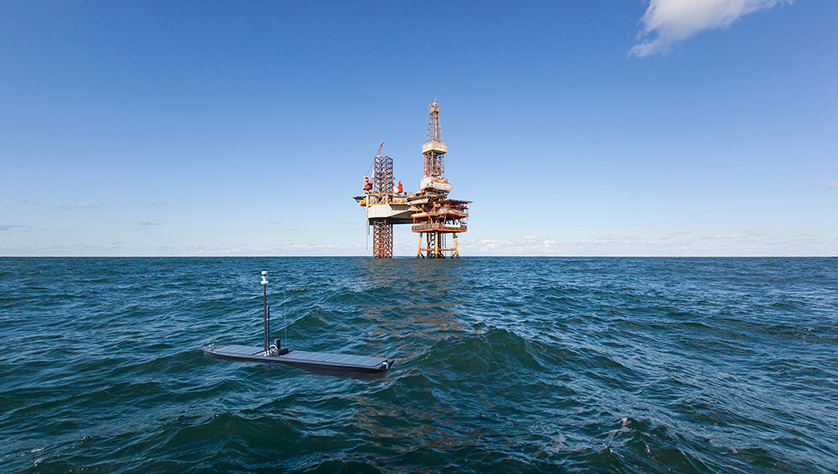
• Seismic Surveys and Weather Condition Surveys: USVs, specifically Wave Gliders<sup>®</sup>, have been used to monitor ocean currents for activities such as seismic surveys as well as the weather conditions around offshore oilrigs. Having the capability to support mixed payloads of METOC sensors, current sensors, acoustic receivers, and communications devices on one platform provides operators with a way to enhance situational awareness and ensure safe maritime operations around multi-billion dollar oil operations.
Changing Climate and Forecast Capabilities with New Systems
Autonomous, unmanned systems provide meteorologists, oceanographers, and scientists with a new and more efficient platform for gathering measurements. While buoys, ships of opportunity, and satellites will continue to play roles in data collection, vehicles like the Wave Glider provide the foundation for cost-efficient systems for long-duration data collection.

Liquid Robotics' Pitcarin Google Earth Journey Map.
They are being used in multiple ways:
• Extended duration sampling with other platforms for climate research – The Council for Scientific and Industrial Research (CSIR)-led Southern Ocean Carbon Climate Observatory (SOCCO) program in South Africa has been using Wave Gliders and buoyancy gliders on multi-month missions to advance climate research in the Southern Ocean.
• Existing long-duration sampling program – Researchers at the Monterey Bay Aquarium Research Institute (MBARI) recently published a paper on the use of Wave Gliders for pCO² and pH observations (i.e., temperature, salinity, oxygen, pCO², pH, wind speed, and direction). They demonstrated how USVs can provide quality datasets that compared favorably to traditional moored and shipboard systems already in use since 1993, offering lower cost data acquisition and greater spatio-temporal coverage¹.
• Long-term observation networks – Today, when a buoy or buoy-based system breaks, the effort to repair it is typically expensive and time consuming, resulting in long periods without measurements. Even when the budget exists, getting boat availability and fixing a buoy can be hampered by weather and resource availability. Unmanned systems that are both mobile and capable of holding station provide a flexible way to increase system uptime. When a system or node has problems, another one can swim out to replace it, which typically allows one showing problems to swim home for inspection or repair.
On the Horizon, the Digital Ocean
The use of autonomous systems has proven invaluable as a way to lower the costs and risks of collecting data needed to advance weather modeling and forecasting. The latest technological advancements that provide intelligent, long-duration, dual-use systems will further help researchers better understand the complex weather conditions driven by the ocean.
As we look to the future, unmanned systems will further transform the way we interact and learn about ocean and, in turn, our planet. Over the next decade, systems will continue to advance in levels of endurance, power, intelligence, and autonomy. However, the scientific breakthroughs required to address weather and global climate change, ocean preservation, maritime security, and other grand challenges will be different. Systems and data will be more interconnected, making the ocean more digital and instant access to ocean data a reality. Imagine the breakthroughs in forecasting for climatologists and meteorologists. With collaboration and continued innovation, it's possible and just over the horizon.
¹ Chavez, F.P., J. Sevadjian, C. Wahl, J. Friederich, and G. E. Friederich. 2017. Measurements of pCO2 and pH from an autonomous surface vehicle in a coastal upwelling system. Deep Sea Research Part II: Topical Studies in Oceanography.