WHOI Scientist Tracking Unexploded Munitions
Ocean News
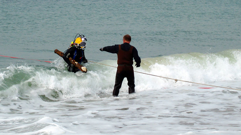
Divers from VRHabilis recover an unexploded munition off South Beach on Martha's Vineyard in 2009. (Elliott Adler, VRHabilis)
Residents of coastal North Carolina woke on Sept. 25 to what you might call an explosive surprise: Hurricane Maria, passing in the night, had churned up two ancient naval munitions from beneath the waves and flung them onto nearby beaches. Crusted with mud, seaweed, and barnacles, the unexploded devices were thought to date from World War II.
Though certainly startling for North Carolina beachgoers, the reappearance of ordnance is actually not so unusual; United States coastlines are riddled with unexploded ordnance, or UXO, left offshore by naval and air force exercises in the 1940s and 1950s. Peter Traykovski, a scientist at Woods Hole Oceanographic Institution, wants to know not only where this ordnance is, but where it might go next.
“We look at the coast as a mobile dynamic environment,” Traykovski says. “People tend to think about it during hurricanes, but forget about it in between. But over long time scales, the tides and waves are gradually working away at our coast. Combine that with a few big storms and some very gradual sea-level change, and in fifty years these problems can really sneak up on you.”
 UXOs Interactive
U.S. coastlines still have a lot of unexploded ordnance, or UXOs, left offshore by military exercises in the 1940s and 1950s. WHOI scientist Peter Traykovski and colleagues are investigating where UXOs are and how they are moved and are buried in different areas and different conditions along the coast. (Eric Taylor, WHOI Graphic Services)
Traykovski’s research focuses on the processes that cause sand and mud on the seafloor to move—via ocean currents, weather patterns, storms, and beach erosion—and what it might carry with it as it does.
Target practice
Traykovski began working on this topic by looking into the movement of buried mines around the time of the Iraq War. His goal then was to help the U.S. Office of Naval Research figure out how quickly mines that had been recently deployed by hostile forces would become buried and more difficult to detect.
Today, his targets are a bit smaller: old training munitions—some broken up by waves or degraded in the ocean over time, but others intact and potentially hazardous. In U.S. waters, these munitions are the remnants of times when air force pilots used then-uninhabited areas for target practice. One area of concern is Martha’s Vineyard.
“We’re looking at what’s now prime real estate on Martha’s Vineyard,” Traykovski says. “It’s hard to imagine when you see these million-dollar mansions that they were using the coast as a firing range in the 1940s and 1950s. So we have all these sites with fragments of old munitions in the marshes and behind the beaches, under the dunes, and potentially out in the surf zone.”
Traykovski is working with the Strategic Environmental Research and Development Program (SERDP)—a consortium program of the Department of Defense, Environmental Protection Agency, and Department of Energy—to try to understand whether these underwater objects will become mobile and potentially end up on land or migrate to other areas that were not used as training areas, or stay where they are and eventually become buried.
“On the land side, we’ve come up with technologies with electromagnetic systems that can actually classify all the buried targets, so we only dig up what is potentially munition,” explains Mike Richardson, a consultant for SERDP and the DOD’s Environmental Security Technology Certification Program on munitions response. “But under the water, what are we going to do? Sending divers down to collect every piece of metal—you can imagine what that could cost. We decrease the cost of remediation if we know where we might need to look. And if a UXO is buried beyond any potential interaction with the public, then people aren’t going to worry about it.”
Where will munitions resurface?
To predict these potential interactions, Traykovski and his colleagues place objects that mimic the different densities of various munitions into the surf zone. Each object is equipped with acoustic trackers. The researchers record the movement of the objects over time, particularly before and after storms. They feed those data into predictive models that integrate information about how sediments will move under particular ocean conditions. For the area around Martha’s Vineyard, Traykovski’s models are backed with more than 15 years of research into how the ocean continually remakes the seafloor there: from the small scale, using acoustic sensors to measure the sliding of sand on the bottom, to the large scale, using robotic boats to map large areas of the seafloor before and after storms.
“Once we understand what goes on in one spot, we think about how to integrate that into the large-scale behavior of the coast,” Traykovski added.
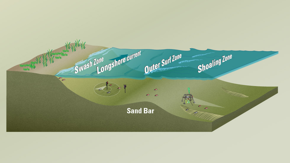
Traykovski has been working alongside a group of scientists with the goal of doing just that: developing a flexible mathematical model to predict how these objects move under different conditions. Each scientist specializes in a different area of the nearshore environment. The swash zone, where waves break onshore, has been the focus of University of Delaware’s Jack Puleo; Traykovski has concentrated on the inner surf zone, between the wave break and the outermost sandbars; and deeper water, out to the continental shelf, is the domain of Joe Calantoni, a research physicist at the U.S. Naval Research Laboratory.
Their work has shown that the fate of each object is highly dependent on its density, with objects closer to the density of water-saturated sand more likely to become mobile in high-energy environments. Time also has a significant influence. If an object has been in an environment with constant wave action for a long time, it would likely have time to become buried; if it’s in a calmer place, it could remain close to the surface and prone to move in a storm.
Traykovski emphasizes that sea level rise and long-term coastal erosion will also play a role in this process. As the ocean moves up the coast, previously stable dunes and marshes containing ordnance will become beachfront, and ordnance can emerge as these areas are eroded away. One of the more surprising discoveries of Calantoni and Traykovski’s work is that many munitions found on beaches don’t come from the ocean at all. They have found that more frequently, munitions buried in the mud or beneath dunes are uncovered by the migration of the coastline as it is reshaped by water and wind.
To save lives and money
Understanding the fate of old ordnance can help predict where beachgoers should be on the lookout for dangerous munitions. It can also save the government millions in the cost of remediation.
The knowledge that munitions will remain buried can be even more valuable than understanding when they might become mobile; this can ensure money isn’t spent on unneeded cleanup efforts. A current effort underway on Martha’s Vineyard, which entails removing several dunes along the Tisbury Great Pond barrier beach to extricate the munitions beneath, will cost the U.S. Army Corps of Engineers $8.1 million.
“Really, what I hope is that we can gain enough understanding and a good-enough model that coastal managers can make the best decisions that not only save lies but also save money,” Calantoni says.
The ultimate goal for the model is to make it flexible enough to work anywhere. Coastal managers could apply it to their region simply by inputting what is known about the region’s munitions and coastal conditions and dynamics.
“We’re not so much looking at specific sites and specific recommendations; it’s more to increase our knowledge about how to approach the problem, which changes from year to year as more research gets conducted,” Traykovski explains. “Our research helps inform these organizations to make the best management decisions and to minimize risk, because ultimately, people want to be able to safely use coastal places without worrying about old hazardous munitions.”